

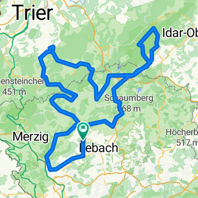
Hochwaldtrail
A cycling route starting in Schmelz, Saarland, Germany.
Overview
About this route
- -:--
- Duration
- 69.7 km
- Distance
- 767 m
- Ascent
- 767 m
- Descent
- ---
- Avg. speed
- ---
- Max. altitude
Continue with Bikemap
Use, edit, or download this cycling route
You would like to ride Hochwaldtrail or customize it for your own trip? Here is what you can do with this Bikemap route:
Free features
- Save this route as favorite or in collections
- Copy & plan your own version of this route
- Sync your route with Garmin or Wahoo
Premium features
Free trial for 3 days, or one-time payment. More about Bikemap Premium.
- Navigate this route on iOS & Android
- Export a GPX / KML file of this route
- Create your custom printout (try it for free)
- Download this route for offline navigation
Discover more Premium features.
Get Bikemap PremiumFrom our community
Other popular routes starting in Schmelz
 2019 Möven geführt 31km
- Distance
- 31.3 km
- Ascent
- 418 m
- Descent
- 418 m
- Location
- Schmelz, Saarland, Germany
 Rund um Schmelz/ Hüttersdorf
- Distance
- 17.6 km
- Ascent
- 188 m
- Descent
- 190 m
- Location
- Schmelz, Saarland, Germany
 Mövenmarathon 2008 - Marathon des RV Möve Schmelz e.V. - 202 km Strecke
- Distance
- 198.6 km
- Ascent
- 2,021 m
- Descent
- 1,834 m
- Location
- Schmelz, Saarland, Germany
 Limbach Hoxfels
- Distance
- 11.7 km
- Ascent
- 282 m
- Descent
- 281 m
- Location
- Schmelz, Saarland, Germany
 Limbach zu Burg Dagstuhl
- Distance
- 21.2 km
- Ascent
- 266 m
- Descent
- 266 m
- Location
- Schmelz, Saarland, Germany
 Wendelinus-Fahrt 2013 - RTF des RSC Haustadter Tal Reimsbach e.V. - 118 km Strecke
- Distance
- 114.7 km
- Ascent
- 1,313 m
- Descent
- 1,246 m
- Location
- Schmelz, Saarland, Germany
 schmelz-staustufe 46km 21,04,2016
- Distance
- 45.8 km
- Ascent
- 260 m
- Descent
- 258 m
- Location
- Schmelz, Saarland, Germany
 Hochwaldtrail
- Distance
- 69.7 km
- Ascent
- 767 m
- Descent
- 767 m
- Location
- Schmelz, Saarland, Germany
Open it in the app