

Shining Sea Bike Path, Falmouth MA
A cycling route starting in North Falmouth, Massachusetts, United States of America.
Overview
About this route
One end of the bike path is in North Falmouth and the other is in Woods Hole. The path follows the old railroad grade so is fairly flat with gradual rises. It is for bicycles, running, roller blades, and walking.
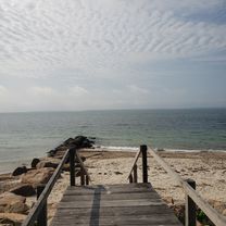
It passes by salt marshes and beaches while traveling through some woods. The views along the path are to the west so the sunset over the salt marshes can be amazing.
There are a number of ice cream shops along the way as well as a few restaurants. Parking lots are at both ends and a few along the way. On weekends during the summer thousands of people use the path during the day, but in early evening the numbers have thinned out. Fall is a great time to see the foliage and relatively few people on the path.
- -:--
- Duration
- 17.1 km
- Distance
- 71 m
- Ascent
- 86 m
- Descent
- ---
- Avg. speed
- ---
- Avg. speed
Continue with Bikemap
Use, edit, or download this cycling route
You would like to ride Shining Sea Bike Path, Falmouth MA or customize it for your own trip? Here is what you can do with this Bikemap route:
Free features
- Save this route as favorite or in collections
- Copy & plan your own version of this route
- Sync your route with Garmin or Wahoo
Premium features
Free trial for 3 days, or one-time payment. More about Bikemap Premium.
- Navigate this route on iOS & Android
- Export a GPX / KML file of this route
- Create your custom printout (try it for free)
- Download this route for offline navigation
Discover more Premium features.
Get Bikemap PremiumFrom our community
Other popular routes starting in North Falmouth
 35 County Rd, North Falmouth to 35 County Rd, North Falmouth
- Distance
- 34.7 km
- Ascent
- 119 m
- Descent
- 120 m
- Location
- North Falmouth, Massachusetts, United States of America
 Shining Sea Bike Path, Falmouth MA CLONED FROM ROUTE 725885
- Distance
- 17.1 km
- Ascent
- 98 m
- Descent
- 114 m
- Location
- North Falmouth, Massachusetts, United States of America
 cape cod canal et bord de mer
- Distance
- 86.3 km
- Ascent
- 177 m
- Descent
- 178 m
- Location
- North Falmouth, Massachusetts, United States of America
 Goeletta Drive 150, Falmouth to Goeletta Drive 154, Falmouth
- Distance
- 41.3 km
- Ascent
- 99 m
- Descent
- 105 m
- Location
- North Falmouth, Massachusetts, United States of America
 Goeletta Drive 154, Falmouth to Goeletta Drive 154, Falmouth
- Distance
- 43.6 km
- Ascent
- 196 m
- Descent
- 193 m
- Location
- North Falmouth, Massachusetts, United States of America
 Cape Cod Century
- Distance
- 163.7 km
- Ascent
- 158 m
- Descent
- 157 m
- Location
- North Falmouth, Massachusetts, United States of America
 Recovered Route
- Distance
- 12.1 km
- Ascent
- 35 m
- Descent
- 39 m
- Location
- North Falmouth, Massachusetts, United States of America
 Depot Rd, North Falmouth to 13 County Rd, North Falmouth
- Distance
- 29.8 km
- Ascent
- 116 m
- Descent
- 110 m
- Location
- North Falmouth, Massachusetts, United States of America
Open it in the app