La Granja de San Ildefonso - Salida por paseo del Pocillo - Vuelta a La Sauca - Subida por Paseo de los Molinillos - Vuelta a los Jardines de la Granja - Prader
A cycling route starting in San Ildefonso, Castille and León, Spain.
Overview
About this route
The start through the village up to beyond the Paseo del Pocillo is paved and downhill.
At Paseo de Casavacas, at the level of the 'horquilla', there is a turn onto a dirt trail with a steady, gentle climb. (a fairly easy loop back to the Sauca).
Return to La Granja to take (on asphalt) the Paseo de los Molinillos. Turn off at the Caserio del Urgel residential area, take the dirt path and begin a steep climb (next to the wall of the palace gardens). After a tough 200-meter climb, on the right there is a gate next to a fence and... the fun begins... descent on a path close to the wall of the palace gardens... (watch out for tree roots as they are very slippery when wet).
Upon reaching a small wooden bridge (where you must dismount to cross), turn onto the path that runs alongside the river. Upon reaching a paved path, take it to the left.
Arrival at Navalhorno and return to La Granja de San Ildefonso via a sandy path next to the CL-601.
- -:--
- Duration
- 16.3 km
- Distance
- 344 m
- Ascent
- 344 m
- Descent
- ---
- Avg. speed
- ---
- Max. altitude
Continue with Bikemap
Use, edit, or download this cycling route
You would like to ride La Granja de San Ildefonso - Salida por paseo del Pocillo - Vuelta a La Sauca - Subida por Paseo de los Molinillos - Vuelta a los Jardines de la Granja - Prader or customize it for your own trip? Here is what you can do with this Bikemap route:
Free features
- Save this route as favorite or in collections
- Copy & plan your own version of this route
- Sync your route with Garmin or Wahoo
Premium features
Free trial for 3 days, or one-time payment. More about Bikemap Premium.
- Navigate this route on iOS & Android
- Export a GPX / KML file of this route
- Create your custom printout (try it for free)
- Download this route for offline navigation
Discover more Premium features.
Get Bikemap PremiumFrom our community
Other popular routes starting in San Ildefonso
- Madrid - Cotos (Alto de Abantos, Puerto de Leones)
- Distance
- 174.9 km
- Ascent
- 1,773 m
- Descent
- 3,357 m
- Location
- San Ildefonso, Castille and León, Spain
- Espagne Riaza - Cotos
- Distance
- 168.5 km
- Ascent
- 2,475 m
- Descent
- 3,529 m
- Location
- San Ildefonso, Castille and León, Spain
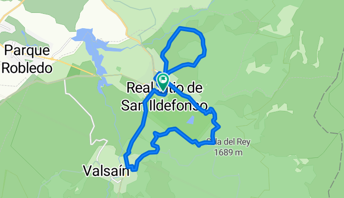
- Navafría y Cotos desde La Granja
- Distance
- 104.2 km
- Ascent
- 1,524 m
- Descent
- 1,524 m
- Location
- San Ildefonso, Castille and León, Spain
- Ruta a Camino del Juego de Bolos, 1–7, San Ildefonso
- Distance
- 10.6 km
- Ascent
- 225 m
- Descent
- 765 m
- Location
- San Ildefonso, Castille and León, Spain
- Campeonato de España en carretera M30 2010
- Distance
- 99.8 km
- Ascent
- 623 m
- Descent
- 626 m
- Location
- San Ildefonso, Castille and León, Spain
- VUELTA A GUADARRAMA, ETAPA 3-1
- Distance
- 15.1 km
- Ascent
- 694 m
- Descent
- 102 m
- Location
- San Ildefonso, Castille and León, Spain
- Peñalara: 5 lagunas-Claveles-2 hermanas
- Distance
- 12.2 km
- Ascent
- 649 m
- Descent
- 653 m
- Location
- San Ildefonso, Castille and León, Spain
- Cerro de la Camorca
- Distance
- 16.3 km
- Ascent
- 979 m
- Descent
- 983 m
- Location
- San Ildefonso, Castille and León, Spain
Open it in the app