

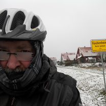
2020-09-04 Wiebelsheim - Westheim - Lenkersheim
A cycling route starting in Bad Windsheim, Bavaria, Germany.
Overview
About this route
- -:--
- Duration
- 23.2 km
- Distance
- 84 m
- Ascent
- 81 m
- Descent
- ---
- Avg. speed
- ---
- Max. altitude

Route quality
Waytypes & surfaces along the route
Waytypes
Quiet road
10 km
(43 %)
Track
7 km
(30 %)
Surfaces
Paved
11.1 km
(48 %)
Unpaved
1.4 km
(6 %)
Paved (undefined)
5.6 km
(24 %)
Asphalt
5.6 km
(24 %)
Continue with Bikemap
Use, edit, or download this cycling route
You would like to ride 2020-09-04 Wiebelsheim - Westheim - Lenkersheim or customize it for your own trip? Here is what you can do with this Bikemap route:
Free features
- Save this route as favorite or in collections
- Copy & plan your own version of this route
- Sync your route with Garmin or Wahoo
Premium features
Free trial for 3 days, or one-time payment. More about Bikemap Premium.
- Navigate this route on iOS & Android
- Export a GPX / KML file of this route
- Create your custom printout (try it for free)
- Download this route for offline navigation
Discover more Premium features.
Get Bikemap PremiumFrom our community
Other popular routes starting in Bad Windsheim
 2024-01-23 Nach Westa und Ickla Stick wegbringen
- Distance
- 16 km
- Ascent
- 61 m
- Descent
- 61 m
- Location
- Bad Windsheim, Bavaria, Germany
 2020-09-04 Wiebelsheim - Westheim - Lenkersheim
- Distance
- 23.2 km
- Ascent
- 84 m
- Descent
- 81 m
- Location
- Bad Windsheim, Bavaria, Germany
 2020-12-10 Kleine Winterrunde
- Distance
- 21.8 km
- Ascent
- 58 m
- Descent
- 57 m
- Location
- Bad Windsheim, Bavaria, Germany
 2020-09-23 Nach Hasenlohe
- Distance
- 38.7 km
- Ascent
- 133 m
- Descent
- 133 m
- Location
- Bad Windsheim, Bavaria, Germany
 2023-04-30 Zu den Gottesdiensten in Rüdisbronn und Kaubenheim
- Distance
- 24 km
- Ascent
- 93 m
- Descent
- 93 m
- Location
- Bad Windsheim, Bavaria, Germany
 Matthäus-Merian-Straße 4, Bad Windsheim to Pfaffenhofen 1, Burgbernheim
- Distance
- 9.7 km
- Ascent
- 75 m
- Descent
- 181 m
- Location
- Bad Windsheim, Bavaria, Germany
 2020-10-21 Ipsheimer Weinberge
- Distance
- 35.4 km
- Ascent
- 159 m
- Descent
- 160 m
- Location
- Bad Windsheim, Bavaria, Germany
 2022-03-19 Aischtalradweg Hinweisschilder und Strecke in Ipsheim Fotografiert
- Distance
- 33.9 km
- Ascent
- 86 m
- Descent
- 87 m
- Location
- Bad Windsheim, Bavaria, Germany
Open it in the app