
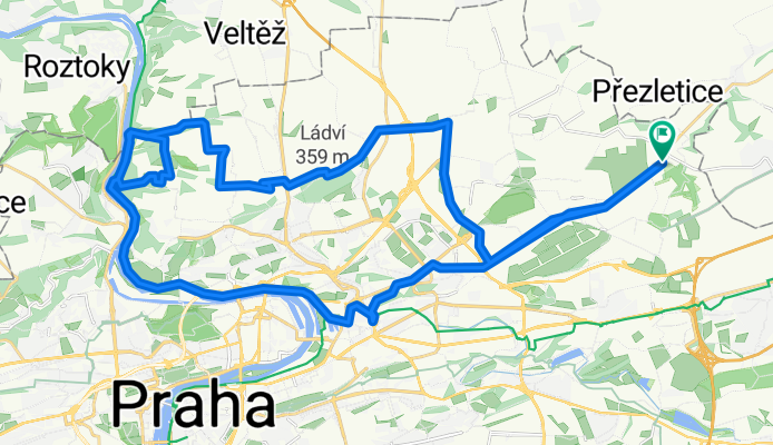
Vinor - Kbely - Dablice - Drahan - Bohnice - Vinor
A cycling route starting in Satalice, Hlavní město Praha, Czechia.
Overview
About this route
Kratka rychla projizdka. Pomer teren/asfalt cca 2/3. Asfalt vyuzit hlavne pro presun do terenu a zpet.
Teren zacina v Dablicich, po prijezdu k Bohnicim se jede chvili po asfaltu, nasledne se vjizdi do terenu na zlutou TZ smerem Drahanske udoli a dolu k vode. Zde smer Trojsky utulek, kde se po modre TZ Bohnickou rokli nahoru do Bohnic. Nasledne sjez po modre TZ do Drahanskeho udoli. Pak uz jen doprava zpet do Vinore - podel reky az k Jisovi, zde vyjez po asfaltu a kus terenem k bobove draze a nasledne uz jen po hlavni az do Vinore.
- -:--
- Duration
- 43.8 km
- Distance
- 308 m
- Ascent
- 308 m
- Descent
- ---
- Avg. speed
- ---
- Max. altitude

Route quality
Waytypes & surfaces along the route
Waytypes
Cycleway
11.1 km
(25 %)
Path
7.2 km
(16 %)
Surfaces
Paved
31.1 km
(71 %)
Unpaved
5 km
(11 %)
Asphalt
24.6 km
(56 %)
Paving stones
5.7 km
(13 %)
Continue with Bikemap
Use, edit, or download this cycling route
You would like to ride Vinor - Kbely - Dablice - Drahan - Bohnice - Vinor or customize it for your own trip? Here is what you can do with this Bikemap route:
Free features
- Save this route as favorite or in collections
- Copy & plan your own version of this route
- Sync your route with Garmin or Wahoo
Premium features
Free trial for 3 days, or one-time payment. More about Bikemap Premium.
- Navigate this route on iOS & Android
- Export a GPX / KML file of this route
- Create your custom printout (try it for free)
- Download this route for offline navigation
Discover more Premium features.
Get Bikemap PremiumFrom our community
Other popular routes starting in Satalice
 Mšeno a z5
- Distance
- 117.9 km
- Ascent
- 646 m
- Descent
- 643 m
- Location
- Satalice, Hlavní město Praha, Czechia
 Vinor - Kbely - Dablice - Drahan - Bohnice - Vinor
- Distance
- 43.8 km
- Ascent
- 308 m
- Descent
- 308 m
- Location
- Satalice, Hlavní město Praha, Czechia
 Vinor - Jilove - Kameny Privoz - Chocerady - Sazava - Skvrnov
- Distance
- 96.9 km
- Ascent
- 691 m
- Descent
- 545 m
- Location
- Satalice, Hlavní město Praha, Czechia
 Satalice a Koloděje
- Distance
- 54.2 km
- Ascent
- 316 m
- Descent
- 437 m
- Location
- Satalice, Hlavní město Praha, Czechia
 Vinoř-Brandýs-Kostelec-Kozly-zpět
- Distance
- 48.3 km
- Ascent
- 129 m
- Descent
- 129 m
- Location
- Satalice, Hlavní město Praha, Czechia
 Vinoř - Říp - Vinoř
- Distance
- 114.4 km
- Ascent
- 609 m
- Descent
- 609 m
- Location
- Satalice, Hlavní město Praha, Czechia
 Praha - Rip - Okor - Praha
- Distance
- 137 km
- Ascent
- 682 m
- Descent
- 683 m
- Location
- Satalice, Hlavní město Praha, Czechia
 Vinor - Budejovicka - cesta do prace
- Distance
- 22 km
- Ascent
- 165 m
- Descent
- 149 m
- Location
- Satalice, Hlavní město Praha, Czechia
Open it in the app