- 49.9 km
- 43 m
- 46 m
- Nierstein, Rhineland-Palatinate, Germany
Nierstein (Rheinhessen) - Donnersberg (Pfalz)
A cycling route starting in Nierstein, Rhineland-Palatinate, Germany.
Overview
About this route
Very nice route along the Selztalradweg to the highest point of the Palatinate, the Donnersberg. Up to Dannenfels, you ride almost exclusively on well-developed and well-signposted cycle paths. (However, the route is not so suitable for road bikes, as some parts of the cycle paths are a bit bumpy.)
- -:--
- Duration
- 59.8 km
- Distance
- 741 m
- Ascent
- 175 m
- Descent
- ---
- Avg. speed
- ---
- Max. altitude
created this 15 years ago
Route quality
Waytypes & surfaces along the route
Waytypes
Track
25.7 km
(43 %)
Quiet road
9 km
(15 %)
Surfaces
Paved
47.9 km
(80 %)
Unpaved
5.4 km
(9 %)
Asphalt
40.7 km
(68 %)
Paved (undefined)
4.2 km
(7 %)
Continue with Bikemap
Use, edit, or download this cycling route
You would like to ride Nierstein (Rheinhessen) - Donnersberg (Pfalz) or customize it for your own trip? Here is what you can do with this Bikemap route:
Free features
- Save this route as favorite or in collections
- Copy & plan your own version of this route
- Sync your route with Garmin or Wahoo
Premium features
Free trial for 3 days, or one-time payment. More about Bikemap Premium.
- Navigate this route on iOS & Android
- Export a GPX / KML file of this route
- Create your custom printout (try it for free)
- Download this route for offline navigation
Discover more Premium features.
Get Bikemap PremiumFrom our community
Other popular routes starting in Nierstein
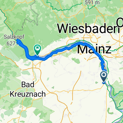
- Nierstein - Kühkopf -Eich -Nierstein
- #14 Nierstein to Bacharach
- 67.7 km
- 73 m
- 88 m
- Nierstein, Rhineland-Palatinate, Germany
- Route im Schneckentempo in Trebur
- 5.8 km
- 0 m
- 4 m
- Nierstein, Rhineland-Palatinate, Germany
- Rheinhessen 11.05.2011
- 78.6 km
- 356 m
- 356 m
- Nierstein, Rhineland-Palatinate, Germany
- Nierstein - Neckarsulm
- 173.5 km
- 1,917 m
- 1,868 m
- Nierstein, Rhineland-Palatinate, Germany
- Rhein - Tag 3 - Nierstein nach Koblenz über Mainz
- 119.7 km
- 909 m
- 930 m
- Nierstein, Rhineland-Palatinate, Germany
- Uttrichstraße, Nierstein nach Grabenstraße, Rüdesheim am Rhein
- 80.7 km
- 477 m
- 484 m
- Nierstein, Rhineland-Palatinate, Germany
- Optimierte Tour
- 78.6 km
- 532 m
- 535 m
- Nierstein, Rhineland-Palatinate, Germany
Open it in the app


