Lachengrat + Glarner Flowtrail
A cycling route starting in Näfels, Canton of Glarus, Switzerland.
Overview
About this route
- -:--
- Duration
- 76.6 km
- Distance
- 1,604 m
- Ascent
- 1,626 m
- Descent
- ---
- Avg. speed
- ---
- Max. altitude
Continue with Bikemap
Use, edit, or download this cycling route
You would like to ride Lachengrat + Glarner Flowtrail or customize it for your own trip? Here is what you can do with this Bikemap route:
Free features
- Save this route as favorite or in collections
- Copy & plan your own version of this route
- Sync your route with Garmin or Wahoo
Premium features
Free trial for 3 days, or one-time payment. More about Bikemap Premium.
- Navigate this route on iOS & Android
- Export a GPX / KML file of this route
- Create your custom printout (try it for free)
- Download this route for offline navigation
Discover more Premium features.
Get Bikemap PremiumFrom our community
Other popular routes starting in Näfels
Lachengrat + Glarner Flowtrail- Distance
- 76.6 km
- Ascent
- 1,604 m
- Descent
- 1,626 m
- Location
- Näfels, Canton of Glarus, Switzerland
Längeneggpass- Distance
- 39.9 km
- Ascent
- 1,345 m
- Descent
- 1,344 m
- Location
- Näfels, Canton of Glarus, Switzerland
Mollis Obersee- Distance
- 12.3 km
- Ascent
- 1,115 m
- Descent
- 573 m
- Location
- Näfels, Canton of Glarus, Switzerland
Rautispitz- Distance
- 56.3 km
- Ascent
- 342 m
- Descent
- 874 m
- Location
- Näfels, Canton of Glarus, Switzerland
Transalp Etappe 1- Distance
- 124.9 km
- Ascent
- 2,348 m
- Descent
- 1,309 m
- Location
- Näfels, Canton of Glarus, Switzerland
Projekt 2014- Distance
- 513.9 km
- Ascent
- 7,453 m
- Descent
- 7,453 m
- Location
- Näfels, Canton of Glarus, Switzerland
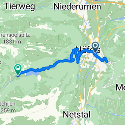
näfels-sool-schwändi-näfels- Distance
- 37.7 km
- Ascent
- 542 m
- Descent
- 541 m
- Location
- Näfels, Canton of Glarus, Switzerland
Percorso rilassato in Näfels- Distance
- 9.6 km
- Ascent
- 53 m
- Descent
- 61 m
- Location
- Näfels, Canton of Glarus, Switzerland
Open it in the app


