
Tyrol 2021 - Etap 3
A cycling route starting in Fieberbrunn, Tyrol, Austria.
Overview
About this route
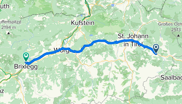
Po całym dniu w Fibrbrun, czas ruszyć na zachód. Etap należy do łatwiejszych. Na niespełna 60 kilometrach, mamy tylko 330 metrów w górę. Jedziemy przez zimowe kurorty, St Johan in Tirol, Wilden Kaiser. Na około 40 kilometrze dojeżdżamy do rzeki Inn. Ostatnie 10 kilometrów do płaski dojazd do miejscowsic Kramsach, gdzie nocujemy.
- -:--
- Duration
- 60 km
- Distance
- 265 m
- Ascent
- 523 m
- Descent
- ---
- Avg. speed
- ---
- Max. altitude

Route photos


Route quality
Waytypes & surfaces along the route
Waytypes
Quiet road
25.8 km
(43 %)
Track
10.8 km
(18 %)
Surfaces
Paved
49.8 km
(83 %)
Unpaved
4.8 km
(8 %)
Asphalt
49.2 km
(82 %)
Loose gravel
4.2 km
(7 %)
Continue with Bikemap
Use, edit, or download this cycling route
You would like to ride Tyrol 2021 - Etap 3 or customize it for your own trip? Here is what you can do with this Bikemap route:
Free features
- Save this route as favorite or in collections
- Copy & plan your own version of this route
- Sync your route with Garmin or Wahoo
Premium features
Free trial for 3 days, or one-time payment. More about Bikemap Premium.
- Navigate this route on iOS & Android
- Export a GPX / KML file of this route
- Create your custom printout (try it for free)
- Download this route for offline navigation
Discover more Premium features.
Get Bikemap PremiumFrom our community
Other popular routes starting in Fieberbrunn
 Harschbichlhütte
- Distance
- 33.5 km
- Ascent
- 1,053 m
- Descent
- 1,054 m
- Location
- Fieberbrunn, Tyrol, Austria
 Kalksteinrunde
- Distance
- 44.1 km
- Ascent
- 319 m
- Descent
- 319 m
- Location
- Fieberbrunn, Tyrol, Austria
 Burgeralm Fieberbrunn
- Distance
- 24.7 km
- Ascent
- 642 m
- Descent
- 646 m
- Location
- Fieberbrunn, Tyrol, Austria
 Run_Buchensteinwandrunde
- Distance
- 18.5 km
- Ascent
- 456 m
- Descent
- 424 m
- Location
- Fieberbrunn, Tyrol, Austria
 Panoramaalm
- Distance
- 42.4 km
- Ascent
- 1,278 m
- Descent
- 1,273 m
- Location
- Fieberbrunn, Tyrol, Austria
 Um die Loferer Steinberge
- Distance
- 66.8 km
- Ascent
- 407 m
- Descent
- 403 m
- Location
- Fieberbrunn, Tyrol, Austria
 Buchensteinwandrunde
- Distance
- 20.4 km
- Ascent
- 283 m
- Descent
- 287 m
- Location
- Fieberbrunn, Tyrol, Austria
 Fieberbrunn - Steinplatte Tour
- Distance
- 74.6 km
- Ascent
- 935 m
- Descent
- 948 m
- Location
- Fieberbrunn, Tyrol, Austria
Open it in the app