
Tyrol 2021 - Etap 5 ( cały dzień w TUX )
A cycling route starting in Mayrhofen, Tyrol, Austria.
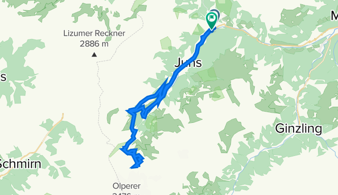
Overview
About this route
Piąty etap naszej wyprawy. Zostajemy na jeden dzień, u podnóża lodowca Hintertux. Jedna z propozycji na całodniową wycieczkę, to własnie podjazd pod "jezyk" lodowca. Bedą równiez inne znacznie łątwiejsze propozycje wycieczek. Rownie dobrze można ten dzień poświęcić na całodniową regeneracje w jednym z licznych SPA, znajdujących sie w dolinie, czy też zdobyć lodowiec za pomocą wagoniku.
- -:--
- Duration
- 32.3 km
- Distance
- 1,312 m
- Ascent
- 1,314 m
- Descent
- ---
- Avg. speed
- ---
- Max. altitude

Route quality
Waytypes & surfaces along the route
Waytypes
Track
16.8 km
(52 %)
Path
2.3 km
(7 %)
Surfaces
Paved
12.9 km
(40 %)
Unpaved
17.5 km
(54 %)
Gravel
14.6 km
(45 %)
Asphalt
12.9 km
(40 %)
Continue with Bikemap
Use, edit, or download this cycling route
You would like to ride Tyrol 2021 - Etap 5 ( cały dzień w TUX ) or customize it for your own trip? Here is what you can do with this Bikemap route:
Free features
- Save this route as favorite or in collections
- Copy & plan your own version of this route
- Sync your route with Garmin or Wahoo
Premium features
Free trial for 3 days, or one-time payment. More about Bikemap Premium.
- Navigate this route on iOS & Android
- Export a GPX / KML file of this route
- Create your custom printout (try it for free)
- Download this route for offline navigation
Discover more Premium features.
Get Bikemap PremiumFrom our community
Other popular routes starting in Mayrhofen
 Stilluptal
- Distance
- 36 km
- Ascent
- 831 m
- Descent
- 829 m
- Location
- Mayrhofen, Tyrol, Austria
 Mayrh. Pfundsalm Fügen
- Distance
- 58.6 km
- Ascent
- 1,657 m
- Descent
- 1,657 m
- Location
- Mayrhofen, Tyrol, Austria
 Zillertaler Berg Klassiker
- Distance
- 120 km
- Ascent
- 2,140 m
- Descent
- 2,101 m
- Location
- Mayrhofen, Tyrol, Austria
 A Mayrhofen 45 rovina
- Distance
- 43.9 km
- Ascent
- 176 m
- Descent
- 175 m
- Location
- Mayrhofen, Tyrol, Austria
 Ahornstraße 855, Mayrhofen nach Stillup 967, Mayrhofen
- Distance
- 15.4 km
- Ascent
- 881 m
- Descent
- 94 m
- Location
- Mayrhofen, Tyrol, Austria
 Steinkasern Junsalm
- Distance
- 8.1 km
- Ascent
- 716 m
- Descent
- 117 m
- Location
- Mayrhofen, Tyrol, Austria
 Bergstation Penken - Ramsau/Hippach
- Distance
- 18.2 km
- Ascent
- 81 m
- Descent
- 1,460 m
- Location
- Mayrhofen, Tyrol, Austria
 Alpencross 2te
- Distance
- 117 km
- Ascent
- 3,629 m
- Descent
- 3,630 m
- Location
- Mayrhofen, Tyrol, Austria
Open it in the app