

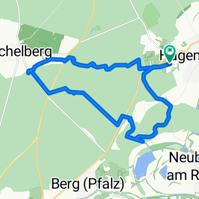
Bienwald
A cycling route starting in Hagenbach, Rhineland-Palatinate, Germany.
Overview
About this route
- -:--
- Duration
- 38.8 km
- Distance
- 87 m
- Ascent
- 86 m
- Descent
- ---
- Avg. speed
- ---
- Max. altitude

Route quality
Waytypes & surfaces along the route
Waytypes
Road
12.8 km
(33 %)
Track
12.1 km
(31 %)
Surfaces
Paved
27.8 km
(72 %)
Unpaved
9.5 km
(24 %)
Asphalt
24.3 km
(63 %)
Gravel
8.5 km
(22 %)
Continue with Bikemap
Use, edit, or download this cycling route
You would like to ride Bienwald or customize it for your own trip? Here is what you can do with this Bikemap route:
Free features
- Save this route as favorite or in collections
- Copy & plan your own version of this route
- Sync your route with Garmin or Wahoo
Premium features
Free trial for 3 days, or one-time payment. More about Bikemap Premium.
- Navigate this route on iOS & Android
- Export a GPX / KML file of this route
- Create your custom printout (try it for free)
- Download this route for offline navigation
Discover more Premium features.
Get Bikemap PremiumFrom our community
Other popular routes starting in Hagenbach
 Hagenbach-Lauterbourg-Wissemburg-Reisdorf-Bad Bergzabern-Kandel-Wörth-Hagenbach
- Distance
- 79.2 km
- Ascent
- 297 m
- Descent
- 299 m
- Location
- Hagenbach, Rhineland-Palatinate, Germany
 Bienwald
- Distance
- 38.8 km
- Ascent
- 87 m
- Descent
- 86 m
- Location
- Hagenbach, Rhineland-Palatinate, Germany
 Hagenbach-Scherhol-Pfaffenschlick-Scherhol-Reisdorf-Offenbach
- Distance
- 113 km
- Ascent
- 803 m
- Descent
- 775 m
- Location
- Hagenbach, Rhineland-Palatinate, Germany
 ggg
ggg- Distance
- 38 km
- Ascent
- 128 m
- Descent
- 127 m
- Location
- Hagenbach, Rhineland-Palatinate, Germany
 Bunkertour Süd-Ost-Pfalz
- Distance
- 15.9 km
- Ascent
- 91 m
- Descent
- 92 m
- Location
- Hagenbach, Rhineland-Palatinate, Germany
 Hagenbach-Lauterbourg-Wissemburg-Reisdorf-Bad Bergzabern-Kandel-Wörth-Hagenbach CLONED FROM ROUTE 737738
- Distance
- 79.3 km
- Ascent
- 297 m
- Descent
- 299 m
- Location
- Hagenbach, Rhineland-Palatinate, Germany
 Hagenbach-Beinheim-Hatten-Scheibenhardt-Hagenbach
- Distance
- 67.4 km
- Ascent
- 105 m
- Descent
- 108 m
- Location
- Hagenbach, Rhineland-Palatinate, Germany
 Hagenbach-Lauterbourg-Wissemburg-Reisdorf-Bad Bergzabern-Kandel-Wörth-Hagenbach CLONED FROM ROUTE 737738
- Distance
- 79.3 km
- Ascent
- 303 m
- Descent
- 306 m
- Location
- Hagenbach, Rhineland-Palatinate, Germany
Open it in the app