

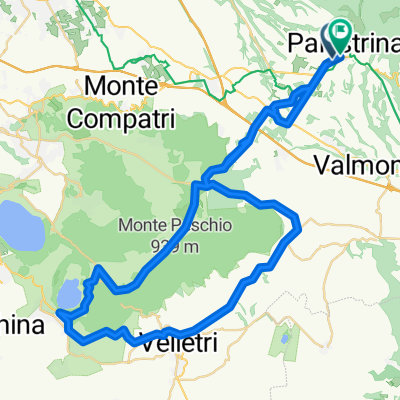
Palestrina-Valmontone-Genazzano-San Vito-Capranica-Palestrina
A cycling route starting in Palestrina, Lazio, Italy.
Overview
About this route
The initial part is a descent down to Valmontone; from there it's a slight uphill to Cave and from Cave to Genazzano it continues with ups and downs. From Genazzano, the climb to San Vito Romano begins, about 7 km long; the slopes are not steep and there are no dizzying sections, it is a simple climb but not to be underestimated because it is quite long. Upon arriving in San Vito, another ascent awaits you, shorter than the previous one and with the same gradient. - if you find the road closed from San Vito to Capranica, don't be discouraged (XD), they have opened a little path for pedestrians and CYCLISTS to pass because the road has collapsed. Upon arriving at Capranica, a well-deserved descent to Palestrina awaits you (lol). If you want, you can visit Castel San Pietro, which is located after Capranica, halfway between Palestrina and the latter.
- -:--
- Duration
- 50.5 km
- Distance
- 1,105 m
- Ascent
- 800 m
- Descent
- ---
- Avg. speed
- 847 m
- Max. altitude

Route quality
Waytypes & surfaces along the route
Waytypes
Road
23.7 km
(47 %)
Quiet road
5 km
(10 %)
Surfaces
Paved
39.4 km
(78 %)
Asphalt
39.4 km
(78 %)
Undefined
11.1 km
(22 %)
Continue with Bikemap
Use, edit, or download this cycling route
You would like to ride Palestrina-Valmontone-Genazzano-San Vito-Capranica-Palestrina or customize it for your own trip? Here is what you can do with this Bikemap route:
Free features
- Save this route as favorite or in collections
- Copy & plan your own version of this route
- Sync your route with Garmin or Wahoo
Premium features
Free trial for 3 days, or one-time payment. More about Bikemap Premium.
- Navigate this route on iOS & Android
- Export a GPX / KML file of this route
- Create your custom printout (try it for free)
- Download this route for offline navigation
Discover more Premium features.
Get Bikemap PremiumFrom our community
Other popular routes starting in Palestrina
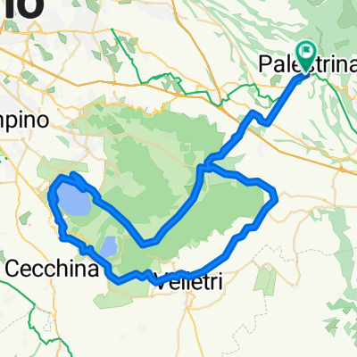
 Palestrina-Valmontone-Genazzano-San Vito-Capranica-Palestrina
- Distance
- 50.5 km
- Ascent
- 1,105 m
- Descent
- 800 m
- Location
- Palestrina, Lazio, Italy
 giro castelli
- Distance
- 64.3 km
- Ascent
- 730 m
- Descent
- 718 m
- Location
- Palestrina, Lazio, Italy
 Palestrina-Valle Martella
- Distance
- 33.4 km
- Ascent
- 485 m
- Descent
- 508 m
- Location
- Palestrina, Lazio, Italy
 Da Via della Muracciola, Palestrina a Via della Muracciola, Palestrina
- Distance
- 0.1 km
- Ascent
- 0 m
- Descent
- 0 m
- Location
- Palestrina, Lazio, Italy
 GUADAMBIOLO
- Distance
- 43.9 km
- Ascent
- 1,074 m
- Descent
- 1,073 m
- Location
- Palestrina, Lazio, Italy
 Via delle Barozze
- Distance
- 59.9 km
- Ascent
- 531 m
- Descent
- 532 m
- Location
- Palestrina, Lazio, Italy
 giro Castengandolfo
- Distance
- 82.4 km
- Ascent
- 864 m
- Descent
- 860 m
- Location
- Palestrina, Lazio, Italy
 Fiuggi, Lago Canterno, Colleferro, Palestrina
- Distance
- 104.5 km
- Ascent
- 916 m
- Descent
- 919 m
- Location
- Palestrina, Lazio, Italy
Open it in the app