

Mooi en pittig Haspengouw Stef
A cycling route starting in Opglabbeek, Flemish Region, Belgium.
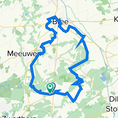
Overview
About this route
Kukkelberg,Kernielberg, Bollenberg, Kolmontberg, Alden Biesen
- -:--
- Duration
- 102.7 km
- Distance
- 765 m
- Ascent
- 771 m
- Descent
- ---
- Avg. speed
- ---
- Max. altitude

Route quality
Waytypes & surfaces along the route
Waytypes
Quiet road
56.1 km
(55 %)
Cycleway
31.3 km
(30 %)
Surfaces
Paved
67 km
(65 %)
Unpaved
1.8 km
(2 %)
Asphalt
43.4 km
(42 %)
Concrete
17.1 km
(17 %)
Continue with Bikemap
Use, edit, or download this cycling route
You would like to ride Mooi en pittig Haspengouw Stef or customize it for your own trip? Here is what you can do with this Bikemap route:
Free features
- Save this route as favorite or in collections
- Copy & plan your own version of this route
- Split it into stages to create a multi-day tour
- Sync your route with Garmin or Wahoo
Premium features
Free trial for 3 days, or one-time payment. More about Bikemap Premium.
- Navigate this route on iOS & Android
- Export a GPX / KML file of this route
- Create your custom printout (try it for free)
- Download this route for offline navigation
Discover more Premium features.
Get Bikemap PremiumFrom our community
Other popular routes starting in Opglabbeek
 Mooi en pittig Haspengouw Stef
- Distance
- 102.7 km
- Ascent
- 765 m
- Descent
- 771 m
- Location
- Opglabbeek, Flemish Region, Belgium
 Opoeteren - Niel-Bij-As - Eisden - Opoeteren
- Distance
- 33.9 km
- Ascent
- 105 m
- Descent
- 109 m
- Location
- Opglabbeek, Flemish Region, Belgium
 29/12
29/12- Distance
- 49.7 km
- Ascent
- 0 m
- Descent
- 0 m
- Location
- Opglabbeek, Flemish Region, Belgium
 Opglabbeek Kanne Voeren Bemelen
- Distance
- 111.8 km
- Ascent
- 989 m
- Descent
- 1,004 m
- Location
- Opglabbeek, Flemish Region, Belgium
 Route in Oudsbergen
- Distance
- 64.3 km
- Ascent
- 277 m
- Descent
- 276 m
- Location
- Opglabbeek, Flemish Region, Belgium
 MaasRood
- Distance
- 23.7 km
- Ascent
- 214 m
- Descent
- 215 m
- Location
- Opglabbeek, Flemish Region, Belgium
 Opoeteren - Opgrimbie - Opoeteren
- Distance
- 66.4 km
- Ascent
- 150 m
- Descent
- 153 m
- Location
- Opglabbeek, Flemish Region, Belgium
 Mooi rondje zuid Limburg.nl Stef Ceys
- Distance
- 106.1 km
- Ascent
- 840 m
- Descent
- 838 m
- Location
- Opglabbeek, Flemish Region, Belgium
Open it in the app