

Oxens gata 239 do Tvillingarnas gata 334
A cycling route starting in Haninge, Stockholm County, Sweden.
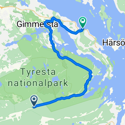
Overview
About this route
- 2 h 41 min
- Duration
- 35.3 km
- Distance
- 227 m
- Ascent
- 238 m
- Descent
- 13.2 km/h
- Avg. speed
- ---
- Max. altitude

Route quality
Waytypes & surfaces along the route
Waytypes
Path
11 km
(31 %)
Cycleway
9 km
(26 %)
Surfaces
Paved
12 km
(34 %)
Unpaved
7.8 km
(22 %)
Asphalt
11.3 km
(32 %)
Gravel
4.5 km
(13 %)
Continue with Bikemap
Use, edit, or download this cycling route
You would like to ride Oxens gata 239 do Tvillingarnas gata 334 or customize it for your own trip? Here is what you can do with this Bikemap route:
Free features
- Save this route as favorite or in collections
- Copy & plan your own version of this route
- Sync your route with Garmin or Wahoo
Premium features
Free trial for 3 days, or one-time payment. More about Bikemap Premium.
- Navigate this route on iOS & Android
- Export a GPX / KML file of this route
- Create your custom printout (try it for free)
- Download this route for offline navigation
Discover more Premium features.
Get Bikemap PremiumFrom our community
Other popular routes starting in Haninge
 Route from bbc
- Distance
- 37.5 km
- Ascent
- 255 m
- Descent
- 260 m
- Location
- Haninge, Stockholm County, Sweden
 Day 4b: Tyresta to Tyresö
- Distance
- 21.9 km
- Ascent
- 304 m
- Descent
- 306 m
- Location
- Haninge, Stockholm County, Sweden
 Brandbergen - Tyresö Slott - Sköndal - Brandbergen
- Distance
- 46.3 km
- Ascent
- 463 m
- Descent
- 460 m
- Location
- Haninge, Stockholm County, Sweden
 Day 4b: Tyresta (Mörby sign) to Tyresö
- Distance
- 21.2 km
- Ascent
- 310 m
- Descent
- 312 m
- Location
- Haninge, Stockholm County, Sweden
 Bävervägen 2, Handen to Drottninggatan 66, Stockholm
- Distance
- 22.5 km
- Ascent
- 171 m
- Descent
- 207 m
- Location
- Haninge, Stockholm County, Sweden
 Hej Till PCC Loeb
- Distance
- 6.2 km
- Ascent
- 42 m
- Descent
- 60 m
- Location
- Haninge, Stockholm County, Sweden
 Oxens gata 239 do Tvillingarnas gata 334
- Distance
- 35.3 km
- Ascent
- 227 m
- Descent
- 238 m
- Location
- Haninge, Stockholm County, Sweden
 Sörmlandsleden Björkhagen - Handen
- Distance
- 36.9 km
- Ascent
- 254 m
- Descent
- 238 m
- Location
- Haninge, Stockholm County, Sweden
Open it in the app