
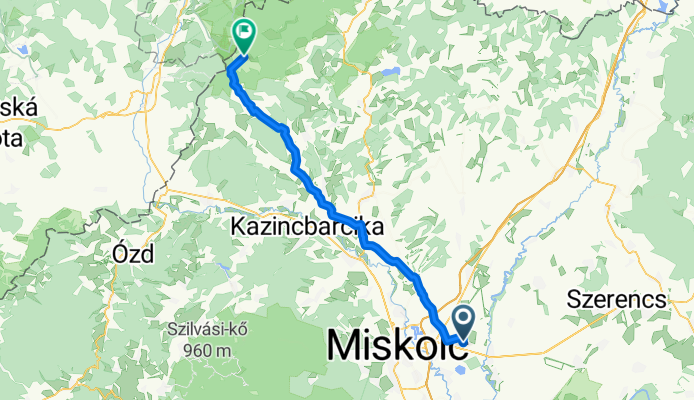
Onga to Aggtelek
A cycling route starting in Onga, Borsod-Abauj Zemplen county, Hungary.
Overview
About this route
- 3 h 49 min
- Duration
- 60.8 km
- Distance
- 552 m
- Ascent
- 324 m
- Descent
- 16 km/h
- Avg. speed
- ---
- Max. altitude

Route photos


Route quality
Waytypes & surfaces along the route
Waytypes
Quiet road
11.6 km
(19 %)
Track
9.1 km
(15 %)
Surfaces
Paved
28.6 km
(47 %)
Asphalt
28 km
(46 %)
Paved (undefined)
0.6 km
(1 %)
Undefined
32.2 km
(53 %)
Continue with Bikemap
Use, edit, or download this cycling route
You would like to ride Onga to Aggtelek or customize it for your own trip? Here is what you can do with this Bikemap route:
Free features
- Save this route as favorite or in collections
- Copy & plan your own version of this route
- Sync your route with Garmin or Wahoo
Premium features
Free trial for 3 days, or one-time payment. More about Bikemap Premium.
- Navigate this route on iOS & Android
- Export a GPX / KML file of this route
- Create your custom printout (try it for free)
- Download this route for offline navigation
Discover more Premium features.
Get Bikemap PremiumFrom our community
Other popular routes starting in Onga
 Onga - Józsi bácsi fagyizója - Alsózsolca
- Distance
- 9.4 km
- Ascent
- 31 m
- Descent
- 31 m
- Location
- Onga, Borsod-Abauj Zemplen county, Hungary
 Onga (HUN) - Igló (SK) gyors/fastest
- Distance
- 143.9 km
- Ascent
- 2,060 m
- Descent
- 1,708 m
- Location
- Onga, Borsod-Abauj Zemplen county, Hungary
 Onga - Paris
- Distance
- 1,768.3 km
- Ascent
- 1,003 m
- Descent
- 1,077 m
- Location
- Onga, Borsod-Abauj Zemplen county, Hungary
 Dózsa György utca 2, Onga - Csokonai utca 2, Budapest
- Distance
- 273.3 km
- Ascent
- 3,074 m
- Descent
- 3,070 m
- Location
- Onga, Borsod-Abauj Zemplen county, Hungary
 Onga - Búza tér - Tricikli Bt.
- Distance
- 9.6 km
- Ascent
- 164 m
- Descent
- 112 m
- Location
- Onga, Borsod-Abauj Zemplen county, Hungary
 Burger King MC
- Distance
- 7.3 km
- Ascent
- 121 m
- Descent
- 122 m
- Location
- Onga, Borsod-Abauj Zemplen county, Hungary
 Onga - Győr
- Distance
- 338.3 km
- Ascent
- 1,193 m
- Descent
- 1,187 m
- Location
- Onga, Borsod-Abauj Zemplen county, Hungary
 Dózsa György utca 2, Onga to Névtelen út, Győr
- Distance
- 378.5 km
- Ascent
- 3,306 m
- Descent
- 3,304 m
- Location
- Onga, Borsod-Abauj Zemplen county, Hungary
Open it in the app