Sandhausen - Schlossplatz Schwetzingen
A cycling route starting in Sandhausen, Baden-Wurttemberg, Germany.
Overview
About this route
- 27 min
- Duration
- 8.1 km
- Distance
- 12 m
- Ascent
- 16 m
- Descent
- 17.8 km/h
- Avg. speed
- ---
- Max. altitude
Route quality
Waytypes & surfaces along the route
Waytypes
Track
4.8 km
(59 %)
Quiet road
2 km
(25 %)
Surfaces
Paved
7.2 km
(89 %)
Asphalt
5 km
(61 %)
Paved (undefined)
2.3 km
(28 %)
Undefined
0.9 km
(11 %)
Continue with Bikemap
Use, edit, or download this cycling route
You would like to ride Sandhausen - Schlossplatz Schwetzingen or customize it for your own trip? Here is what you can do with this Bikemap route:
Free features
- Save this route as favorite or in collections
- Copy & plan your own version of this route
- Sync your route with Garmin or Wahoo
Premium features
Free trial for 3 days, or one-time payment. More about Bikemap Premium.
- Navigate this route on iOS & Android
- Export a GPX / KML file of this route
- Create your custom printout (try it for free)
- Download this route for offline navigation
Discover more Premium features.
Get Bikemap PremiumFrom our community
Other popular routes starting in Sandhausen
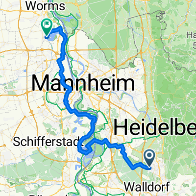
- RTF Kurt Sattel Rundfahrt des MSC St. Ilgen e.V. im ADAC - 78 km Strecke
- Distance
- 79.2 km
- Ascent
- 553 m
- Descent
- 549 m
- Location
- Sandhausen, Baden-Wurttemberg, Germany
- Sandhäuser Permanente 2016 - 75 km Perm. des RC 1902 Badenia Sandhausen e.V.
- Distance
- 76.4 km
- Ascent
- 336 m
- Descent
- 336 m
- Location
- Sandhausen, Baden-Wurttemberg, Germany
- Hardtwaldrunde
- Distance
- 24.6 km
- Ascent
- 58 m
- Descent
- 60 m
- Location
- Sandhausen, Baden-Wurttemberg, Germany
- Hochzeitstag Tour ❤️
- Distance
- 19.5 km
- Ascent
- 6 m
- Descent
- 6 m
- Location
- Sandhausen, Baden-Wurttemberg, Germany
- Im Sommer wenn de Fitt bist!
- Distance
- 80.3 km
- Ascent
- 1,102 m
- Descent
- 992 m
- Location
- Sandhausen, Baden-Wurttemberg, Germany
- Drei "Berge" -Tour
- Distance
- 80.4 km
- Ascent
- 955 m
- Descent
- 953 m
- Location
- Sandhausen, Baden-Wurttemberg, Germany
- Ahnenroute 495km - Tag 2 - von Sandhausen nach Büttelborn
- Distance
- 79.7 km
- Ascent
- 154 m
- Descent
- 168 m
- Location
- Sandhausen, Baden-Wurttemberg, Germany
- von Sandhausen>Speyer>Hockenheim>Sandhausen
- Distance
- 46.8 km
- Ascent
- 155 m
- Descent
- 155 m
- Location
- Sandhausen, Baden-Wurttemberg, Germany
Open it in the app