

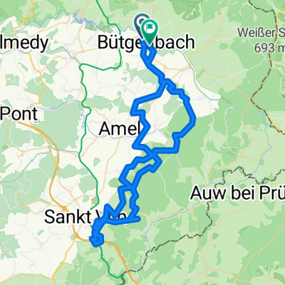
Schöne Meyeroder Tour
A cycling route starting in Butgenbach, Wallonia, Belgium.
Overview
About this route
Top
- -:--
- Duration
- 64.1 km
- Distance
- 731 m
- Ascent
- 721 m
- Descent
- ---
- Avg. speed
- ---
- Max. altitude

Continue with Bikemap
Use, edit, or download this cycling route
You would like to ride Schöne Meyeroder Tour or customize it for your own trip? Here is what you can do with this Bikemap route:
Free features
- Save this route as favorite or in collections
- Copy & plan your own version of this route
- Sync your route with Garmin or Wahoo
Premium features
Free trial for 3 days, or one-time payment. More about Bikemap Premium.
- Navigate this route on iOS & Android
- Export a GPX / KML file of this route
- Create your custom printout (try it for free)
- Download this route for offline navigation
Discover more Premium features.
Get Bikemap PremiumFrom our community
Other popular routes starting in Butgenbach
 Eifel route
- Distance
- 105.5 km
- Ascent
- 972 m
- Descent
- 972 m
- Location
- Butgenbach, Wallonia, Belgium
 VB Butgenbach Lake to Weywerdt
- Distance
- 17.3 km
- Ascent
- 109 m
- Descent
- 136 m
- Location
- Butgenbach, Wallonia, Belgium
 Butgenbach
- Distance
- 22.3 km
- Ascent
- 236 m
- Descent
- 240 m
- Location
- Butgenbach, Wallonia, Belgium
 Von Bütgenbach bis Aachen
- Distance
- 71.1 km
- Ascent
- 303 m
- Descent
- 696 m
- Location
- Butgenbach, Wallonia, Belgium
 Bütgenbach - Steffeshausen - Sankt Vith - Bütgenbach
- Distance
- 88 km
- Ascent
- 500 m
- Descent
- 503 m
- Location
- Butgenbach, Wallonia, Belgium
 Parcours Vert
- Distance
- 12.3 km
- Ascent
- 244 m
- Descent
- 150 m
- Location
- Butgenbach, Wallonia, Belgium
 Butgenbach-Gulpen 80Km
- Distance
- 80.5 km
- Ascent
- 536 m
- Descent
- 965 m
- Location
- Butgenbach, Wallonia, Belgium
 Von Bütgenbach bis Amel
- Distance
- 70.6 km
- Ascent
- 1,315 m
- Descent
- 1,309 m
- Location
- Butgenbach, Wallonia, Belgium
Open it in the app