

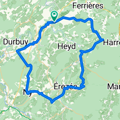
Domaine de Palogne
A cycling route starting in Hamoir, Wallonia, Belgium.
Overview
About this route
90% offroad, 10% route
Distance 37.3 km, elevation gain 759 m
Starting from Domaine de Palogne, follow the river on the left bank along the Ravel path to Bomal, then follow the track to 'Vincent bois' and begin a nice warm-up climb on a shale path with some nice stones. Be careful on the descents as the protruding stones are quite sharp and slippery. The climbs and descents continue towards the Ozo goat farm where you can taste their delicious cheeses. The route proceeds towards Villers-Sainte-Gertrude and Vieux Fourneau. Along the way, discover the Vieux Fourneau stream, a splendid valley that will certainly dazzle you. This is where it gets tougher with the biggest elevation gain on the course. Once at the top, it descends towards Izier behind the houses towards Vieuxville. The small technical passage will delight enthusiasts; for others, an escape route is possible via the main trail. At the place called la résurgence de la Lembrée, cross the small bridge to the main road and stay on the sidewalk; the route keeps to the path on the right. A bit higher up, you cross this main road to continue on the main path. Another nice climb! At the summit, you find yourself in the meadows above My; small country paths will lead you back to Domaine de Palogne without many more difficulties.
- -:--
- Duration
- 37.1 km
- Distance
- 757 m
- Ascent
- 762 m
- Descent
- ---
- Avg. speed
- ---
- Max. altitude

Route quality
Waytypes & surfaces along the route
Waytypes
Track
21.5 km
(58 %)
Path
5.9 km
(16 %)
Surfaces
Paved
9.3 km
(25 %)
Unpaved
24.5 km
(66 %)
Unpaved (undefined)
11.5 km
(31 %)
Ground
9.3 km
(25 %)
Continue with Bikemap
Use, edit, or download this cycling route
You would like to ride Domaine de Palogne or customize it for your own trip? Here is what you can do with this Bikemap route:
Free features
- Save this route as favorite or in collections
- Copy & plan your own version of this route
- Sync your route with Garmin or Wahoo
Premium features
Free trial for 3 days, or one-time payment. More about Bikemap Premium.
- Navigate this route on iOS & Android
- Export a GPX / KML file of this route
- Create your custom printout (try it for free)
- Download this route for offline navigation
Discover more Premium features.
Get Bikemap PremiumFrom our community
Other popular routes starting in Hamoir
 VR6 Hamoir Sy Eupen 90
- Distance
- 89.7 km
- Ascent
- 827 m
- Descent
- 708 m
- Location
- Hamoir, Wallonia, Belgium
 Domaine de Palogne
- Distance
- 37.1 km
- Ascent
- 757 m
- Descent
- 762 m
- Location
- Hamoir, Wallonia, Belgium
 durbuy aisne
- Distance
- 49.1 km
- Ascent
- 838 m
- Descent
- 837 m
- Location
- Hamoir, Wallonia, Belgium
 12pink04
- Distance
- 62 km
- Ascent
- 730 m
- Descent
- 750 m
- Location
- Hamoir, Wallonia, Belgium
 hamoir - Hasselt
- Distance
- 94.7 km
- Ascent
- 371 m
- Descent
- 462 m
- Location
- Hamoir, Wallonia, Belgium
 Au-Dessus des Hans, Durbuy naar Au-Dessus des Hans, Durbuy
- Distance
- 49 km
- Ascent
- 808 m
- Descent
- 811 m
- Location
- Hamoir, Wallonia, Belgium
 rondje hamoir
- Distance
- 56.1 km
- Ascent
- 641 m
- Descent
- 639 m
- Location
- Hamoir, Wallonia, Belgium
 HAMOIR/OUFFET
- Distance
- 17.2 km
- Ascent
- 221 m
- Descent
- 222 m
- Location
- Hamoir, Wallonia, Belgium
Open it in the app