

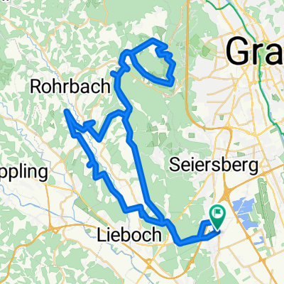
Europaweg 4–5, Unterpremstätten-Zettling nach Doblegg 58, Hitzendorf
A cycling route starting in Unterpremstätten, Styria, Austria.
Overview
About this route
- 43 min
- Duration
- 15.6 km
- Distance
- 237 m
- Ascent
- 113 m
- Descent
- 22 km/h
- Avg. speed
- ---
- Max. altitude
Route quality
Waytypes & surfaces along the route
Waytypes
Quiet road
8 km
(51 %)
Road
3.1 km
(20 %)
Surfaces
Paved
3 km
(19 %)
Unpaved
0.3 km
(2 %)
Asphalt
3 km
(19 %)
Ground
0.3 km
(2 %)
Undefined
12.3 km
(79 %)
Continue with Bikemap
Use, edit, or download this cycling route
You would like to ride Europaweg 4–5, Unterpremstätten-Zettling nach Doblegg 58, Hitzendorf or customize it for your own trip? Here is what you can do with this Bikemap route:
Free features
- Save this route as favorite or in collections
- Copy & plan your own version of this route
- Sync your route with Garmin or Wahoo
Premium features
Free trial for 3 days, or one-time payment. More about Bikemap Premium.
- Navigate this route on iOS & Android
- Export a GPX / KML file of this route
- Create your custom printout (try it for free)
- Download this route for offline navigation
Discover more Premium features.
Get Bikemap PremiumFrom our community
Other popular routes starting in Unterpremstätten
 Die Südrunde
- Distance
- 55.7 km
- Ascent
- 159 m
- Descent
- 159 m
- Location
- Unterpremstätten, Styria, Austria
 Schwarzlsee - Wildon - Kirchberg - St. Margarethen - Nestelbach - Schwarzlsee
- Distance
- 88.4 km
- Ascent
- 946 m
- Descent
- 953 m
- Location
- Unterpremstätten, Styria, Austria
 Steiermark 3 - Südliche Mur
- Distance
- 76.7 km
- Ascent
- 172 m
- Descent
- 176 m
- Location
- Unterpremstätten, Styria, Austria
 Unterpremstätten-Wetzelsdorf-Preding-Lamberg-Steindorf-Wundschuh-Unterpremstätten
- Distance
- 44.4 km
- Ascent
- 0 m
- Descent
- 0 m
- Location
- Unterpremstätten, Styria, Austria
 Über die süd-westl Hügeln
- Distance
- 54 km
- Ascent
- 564 m
- Descent
- 564 m
- Location
- Unterpremstätten, Styria, Austria
 Kalsdorf - Muttendorf - Dobl - Unterpremstätten
- Distance
- 46.9 km
- Ascent
- 239 m
- Descent
- 249 m
- Location
- Unterpremstätten, Styria, Austria
 Die West-Tour
- Distance
- 76.9 km
- Ascent
- 1,066 m
- Descent
- 1,064 m
- Location
- Unterpremstätten, Styria, Austria
 Steiermark 2 - Westl. Steiermark
- Distance
- 56.4 km
- Ascent
- 535 m
- Descent
- 535 m
- Location
- Unterpremstätten, Styria, Austria
Open it in the app