
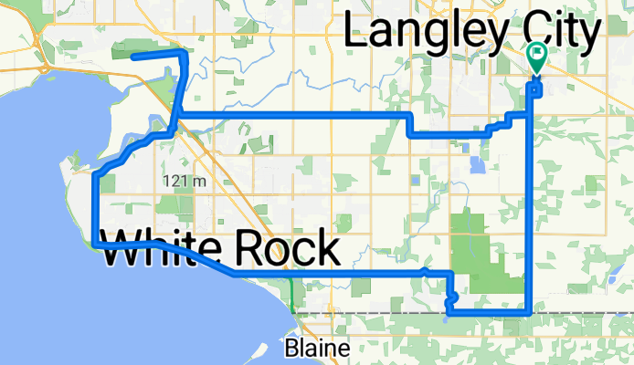
20/09/20
A cycling route starting in Township of Langley, British Columbia, Canada.
Overview
About this route
- 2 h 43 min
- Duration
- 64.9 km
- Distance
- 101 m
- Ascent
- 141 m
- Descent
- 23.9 km/h
- Avg. speed
- ---
- Max. altitude
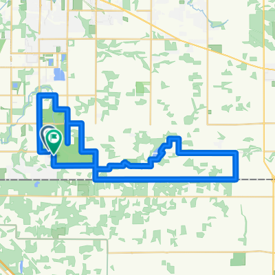
Route quality
Waytypes & surfaces along the route
Waytypes
Road
17.5 km
(27 %)
Quiet road
6.5 km
(10 %)
Surfaces
Paved
59.7 km
(92 %)
Asphalt
59.7 km
(92 %)
Undefined
5.2 km
(8 %)
Continue with Bikemap
Use, edit, or download this cycling route
You would like to ride 20/09/20 or customize it for your own trip? Here is what you can do with this Bikemap route:
Free features
- Save this route as favorite or in collections
- Copy & plan your own version of this route
- Sync your route with Garmin or Wahoo
Premium features
Free trial for 3 days, or one-time payment. More about Bikemap Premium.
- Navigate this route on iOS & Android
- Export a GPX / KML file of this route
- Create your custom printout (try it for free)
- Download this route for offline navigation
Discover more Premium features.
Get Bikemap PremiumFrom our community
Other popular routes starting in Township of Langley
 24245 61st Ave, Langley to 24245 61st Ave, Langley
- Distance
- 23.7 km
- Ascent
- 205 m
- Descent
- 202 m
- Location
- Township of Langley, British Columbia, Canada
 20/09/20
- Distance
- 64.9 km
- Ascent
- 101 m
- Descent
- 141 m
- Location
- Township of Langley, British Columbia, Canada
 Vancouver to Granby through the USA
- Distance
- 3,686.4 km
- Ascent
- 6,099 m
- Descent
- 4,941 m
- Location
- Township of Langley, British Columbia, Canada
 rolling rural
- Distance
- 38.8 km
- Ascent
- 203 m
- Descent
- 203 m
- Location
- Township of Langley, British Columbia, Canada
 Route in Langley
- Distance
- 37.6 km
- Ascent
- 275 m
- Descent
- 274 m
- Location
- Township of Langley, British Columbia, Canada
 125 training ride
- Distance
- 124.7 km
- Ascent
- 329 m
- Descent
- 329 m
- Location
- Township of Langley, British Columbia, Canada
 new way to Ladner
- Distance
- 88.6 km
- Ascent
- 314 m
- Descent
- 312 m
- Location
- Township of Langley, British Columbia, Canada
 guildford tocampbell valley park
- Distance
- 50.3 km
- Ascent
- 416 m
- Descent
- 449 m
- Location
- Township of Langley, British Columbia, Canada
Open it in the app