

tlaxinacalpan.
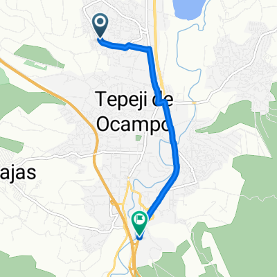
A cycling route starting in Tepeji del Río de Ocampo, Hidalgo, Mexico.
Overview
About this route
- 1 h 5 min
- Duration
- 11 km
- Distance
- 162 m
- Ascent
- 174 m
- Descent
- 10.1 km/h
- Avg. speed
- ---
- Max. altitude

Route photos


Route quality
Waytypes & surfaces along the route
Waytypes
Quiet road
10.5 km
(96 %)
Road
0.4 km
(4 %)
Continue with Bikemap
Use, edit, or download this cycling route
You would like to ride tlaxinacalpan. or customize it for your own trip? Here is what you can do with this Bikemap route:
Free features
- Save this route as favorite or in collections
- Copy & plan your own version of this route
- Sync your route with Garmin or Wahoo
Premium features
Free trial for 3 days, or one-time payment. More about Bikemap Premium.
- Navigate this route on iOS & Android
- Export a GPX / KML file of this route
- Create your custom printout (try it for free)
- Download this route for offline navigation
Discover more Premium features.
Get Bikemap PremiumFrom our community
Other popular routes starting in Tepeji del Río de Ocampo
 TEPEJI DEL RIO -CDMX regreso
- Distance
- 66.6 km
- Ascent
- 583 m
- Descent
- 480 m
- Location
- Tepeji del Río de Ocampo, Hidalgo, Mexico
 De Calle José María Morelos a Hidalgo
- Distance
- 5.5 km
- Ascent
- 84 m
- Descent
- 122 m
- Location
- Tepeji del Río de Ocampo, Hidalgo, Mexico
 De Reforma Agraria 246, Tepeji del Rio de Ocampo à Reforma Agraria 437, Tepeji del Rio de Ocampo
- Distance
- 21.2 km
- Ascent
- 210 m
- Descent
- 214 m
- Location
- Tepeji del Río de Ocampo, Hidalgo, Mexico
 Ruta 1 Tepeji
- Distance
- 16.6 km
- Ascent
- 168 m
- Descent
- 170 m
- Location
- Tepeji del Río de Ocampo, Hidalgo, Mexico
 De Ignacio Ramírez 3, Tepeji del Rio de Ocampo a Nogal 380, Tepeji del Rio de Ocampo
- Distance
- 5.2 km
- Ascent
- 101 m
- Descent
- 107 m
- Location
- Tepeji del Río de Ocampo, Hidalgo, Mexico
 Recovered Route
- Distance
- 18.7 km
- Ascent
- 401 m
- Descent
- 189 m
- Location
- Tepeji del Río de Ocampo, Hidalgo, Mexico
 tlaxinacalpan.
- Distance
- 11 km
- Ascent
- 162 m
- Descent
- 174 m
- Location
- Tepeji del Río de Ocampo, Hidalgo, Mexico
 De Fco I Madero 4, Tepeji del Rio de Ocampo a Del Trabajo 81, Tepeji del Rio de Ocampo
- Distance
- 10.9 km
- Ascent
- 155 m
- Descent
- 156 m
- Location
- Tepeji del Río de Ocampo, Hidalgo, Mexico
Open it in the app