

Tualatin Valley Scenic Bikeway
A cycling route starting in Hillsboro, Oregon, United States.
Overview
About this route
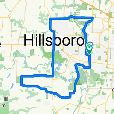
See Traveloregon.com for detailed map and cuesheet. Starts south of Hillsboro, through Forest Grove, and ends at the southern terminus of the Banks-Vernonia State Trail.
- -:--
- Duration
- 47.5 km
- Distance
- 83 m
- Ascent
- 67 m
- Descent
- ---
- Avg. speed
- ---
- Max. altitude

Route quality
Waytypes & surfaces along the route
Waytypes
Road
29.7 km
(62 %)
Busy road
11.2 km
(24 %)
Surfaces
Paved
45.5 km
(96 %)
Asphalt
45.5 km
(96 %)
Concrete
0 km
(<1 %)
Undefined
2 km
(4 %)
Continue with Bikemap
Use, edit, or download this cycling route
You would like to ride Tualatin Valley Scenic Bikeway or customize it for your own trip? Here is what you can do with this Bikemap route:
Free features
- Save this route as favorite or in collections
- Copy & plan your own version of this route
- Sync your route with Garmin or Wahoo
Premium features
Free trial for 3 days, or one-time payment. More about Bikemap Premium.
- Navigate this route on iOS & Android
- Export a GPX / KML file of this route
- Create your custom printout (try it for free)
- Download this route for offline navigation
Discover more Premium features.
Get Bikemap PremiumFrom our community
Other popular routes starting in Hillsboro
 Southeast 5th Avenue 134, Hillsboro to Northeast Harvest Street 5845, Hillsboro
- Distance
- 17 km
- Ascent
- 69 m
- Descent
- 43 m
- Location
- Hillsboro, Oregon, United States
 Shute Park 17.89 miles
- Distance
- 28.7 km
- Ascent
- 91 m
- Descent
- 91 m
- Location
- Hillsboro, Oregon, United States
 Thursday 25
- Distance
- 40.2 km
- Ascent
- 90 m
- Descent
- 90 m
- Location
- Hillsboro, Oregon, United States
 Hillsboro Loop
- Distance
- 35.4 km
- Ascent
- 98 m
- Descent
- 93 m
- Location
- Hillsboro, Oregon, United States
 1132 SE Fir Grove Loop, Hillsboro to 1132 SE Fir Grove Loop, Hillsboro
- Distance
- 27.8 km
- Ascent
- 105 m
- Descent
- 103 m
- Location
- Hillsboro, Oregon, United States
 25 mile
- Distance
- 39.2 km
- Ascent
- 100 m
- Descent
- 99 m
- Location
- Hillsboro, Oregon, United States
 843 NE Birchaire Ln, Hillsboro to 843 NE Birchaire Ln, Hillsboro
- Distance
- 5 km
- Ascent
- 33 m
- Descent
- 39 m
- Location
- Hillsboro, Oregon, United States
 Steady ride in Hillsboro
- Distance
- 15 km
- Ascent
- 78 m
- Descent
- 76 m
- Location
- Hillsboro, Oregon, United States
Open it in the app