
Stoneman MTB C-Version
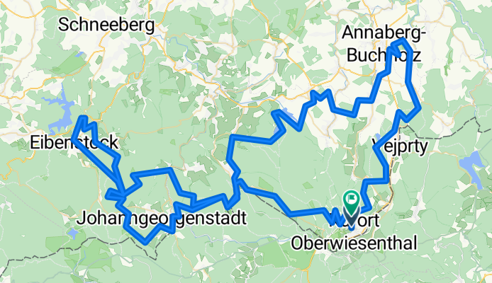
A cycling route starting in Oberwiesenthal, Saxony, Germany.
Overview
About this route
- -:--
- Duration
- 162.6 km
- Distance
- 4,562 m
- Ascent
- 4,487 m
- Descent
- ---
- Avg. speed
- ---
- Max. altitude

Route quality
Waytypes & surfaces along the route
Waytypes
Track
101.6 km
(63 %)
Quiet road
30.1 km
(19 %)
Surfaces
Paved
44.4 km
(27 %)
Unpaved
99.5 km
(61 %)
Gravel
50.6 km
(31 %)
Asphalt
37.3 km
(23 %)
Continue with Bikemap
Use, edit, or download this cycling route
You would like to ride Stoneman MTB C-Version or customize it for your own trip? Here is what you can do with this Bikemap route:
Free features
- Save this route as favorite or in collections
- Copy & plan your own version of this route
- Split it into stages to create a multi-day tour
- Sync your route with Garmin or Wahoo
Premium features
Free trial for 3 days, or one-time payment. More about Bikemap Premium.
- Navigate this route on iOS & Android
- Export a GPX / KML file of this route
- Create your custom printout (try it for free)
- Download this route for offline navigation
Discover more Premium features.
Get Bikemap PremiumFrom our community
Other popular routes starting in Oberwiesenthal
 Oberwiesenthal - Keilberg-Fichtelberg
- Distance
- 37.3 km
- Ascent
- 1,011 m
- Descent
- 1,010 m
- Location
- Oberwiesenthal, Saxony, Germany
 Den 2 - Fichtelberg - Cranzahl
- Distance
- 19.5 km
- Ascent
- 120 m
- Descent
- 682 m
- Location
- Oberwiesenthal, Saxony, Germany
 Krušné hory dle Krausáka
- Distance
- 82.1 km
- Ascent
- 1,151 m
- Descent
- 1,136 m
- Location
- Oberwiesenthal, Saxony, Germany
 Stoneman
- Distance
- 165.5 km
- Ascent
- 2,840 m
- Descent
- 2,822 m
- Location
- Oberwiesenthal, Saxony, Germany
 Stoneman Miriquidi
- Distance
- 162.7 km
- Ascent
- 2,836 m
- Descent
- 2,813 m
- Location
- Oberwiesenthal, Saxony, Germany
 Fichtelberg - Chemnitz
- Distance
- 83.8 km
- Ascent
- 668 m
- Descent
- 1,529 m
- Location
- Oberwiesenthal, Saxony, Germany
 Bozi Dar - Cervena Jama - Bozi Dar
- Distance
- 24 km
- Ascent
- 272 m
- Descent
- 272 m
- Location
- Oberwiesenthal, Saxony, Germany
 Große Sonntagsrunde
- Distance
- 141.2 km
- Ascent
- 2,092 m
- Descent
- 2,335 m
- Location
- Oberwiesenthal, Saxony, Germany
Open it in the app