

Pętla Zachodnia
A cycling route starting in Sidzina, Lesser Poland Voivodeship, Poland.
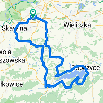
Overview
About this route
The descents in the forest in Rudań Landscape Park are poetry.
- -:--
- Duration
- 77.3 km
- Distance
- 279 m
- Ascent
- 278 m
- Descent
- ---
- Avg. speed
- ---
- Max. altitude
Route quality
Waytypes & surfaces along the route
Waytypes
Road
25.5 km
(33 %)
Quiet road
21.6 km
(28 %)
Surfaces
Paved
55.7 km
(72 %)
Unpaved
19.3 km
(25 %)
Asphalt
54.9 km
(71 %)
Gravel
9.3 km
(12 %)
Route highlights
Points of interest along the route

Point of interest after 19.4 km
Mnikowska Valley. Place of worship and beautiful nature.

Point of interest after 41.7 km
Helm's Deep

Point of interest after 41.9 km
Nice view on Vistula.
Continue with Bikemap
Use, edit, or download this cycling route
You would like to ride Pętla Zachodnia or customize it for your own trip? Here is what you can do with this Bikemap route:
Free features
- Save this route as favorite or in collections
- Copy & plan your own version of this route
- Sync your route with Garmin or Wahoo
Premium features
Free trial for 3 days, or one-time payment. More about Bikemap Premium.
- Navigate this route on iOS & Android
- Export a GPX / KML file of this route
- Create your custom printout (try it for free)
- Download this route for offline navigation
Discover more Premium features.
Get Bikemap PremiumFrom our community
Other popular routes starting in Sidzina
 Borkowska, Kraków to Wodna, Kraków
- Distance
- 9.3 km
- Ascent
- 10 m
- Descent
- 57 m
- Location
- Sidzina, Lesser Poland Voivodeship, Poland
 Trasa2
- Distance
- 36.2 km
- Ascent
- 114 m
- Descent
- 134 m
- Location
- Sidzina, Lesser Poland Voivodeship, Poland
 Tour de Balice
- Distance
- 53.7 km
- Ascent
- 287 m
- Descent
- 286 m
- Location
- Sidzina, Lesser Poland Voivodeship, Poland
 Trasa przed maturą
- Distance
- 89 km
- Ascent
- 815 m
- Descent
- 815 m
- Location
- Sidzina, Lesser Poland Voivodeship, Poland
 Route from Drukarska 21, Kraków
- Distance
- 27.1 km
- Ascent
- 201 m
- Descent
- 204 m
- Location
- Sidzina, Lesser Poland Voivodeship, Poland
 Piltza - Brandysówka
- Distance
- 29.4 km
- Ascent
- 259 m
- Descent
- 168 m
- Location
- Sidzina, Lesser Poland Voivodeship, Poland
 trasa na zaporę
- Distance
- 48.9 km
- Ascent
- 119 m
- Descent
- 119 m
- Location
- Sidzina, Lesser Poland Voivodeship, Poland
 Pętla Zachodnia
- Distance
- 77.3 km
- Ascent
- 279 m
- Descent
- 278 m
- Location
- Sidzina, Lesser Poland Voivodeship, Poland
Open it in the app