

삼송동 18−10, 고양시 to 삼송동 20−27, 고양시
A cycling route starting in Goyang-si, Gyeonggi-do, South Korea.
Overview
About this route
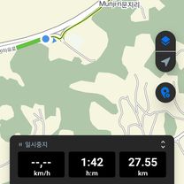
- 5 h
- Duration
- 74.1 km
- Distance
- 445 m
- Ascent
- 445 m
- Descent
- 14.8 km/h
- Avg. speed
- ---
- Max. altitude

Route quality
Waytypes & surfaces along the route
Waytypes
Cycleway
32.6 km
(44 %)
Quiet road
27.4 km
(37 %)
Surfaces
Paved
28.9 km
(39 %)
Unpaved
2.2 km
(3 %)
Asphalt
23 km
(31 %)
Paved (undefined)
3.7 km
(5 %)
Continue with Bikemap
Use, edit, or download this cycling route
You would like to ride 삼송동 18−10, 고양시 to 삼송동 20−27, 고양시 or customize it for your own trip? Here is what you can do with this Bikemap route:
Free features
- Save this route as favorite or in collections
- Copy & plan your own version of this route
- Sync your route with Garmin or Wahoo
Premium features
Free trial for 3 days, or one-time payment. More about Bikemap Premium.
- Navigate this route on iOS & Android
- Export a GPX / KML file of this route
- Create your custom printout (try it for free)
- Download this route for offline navigation
Discover more Premium features.
Get Bikemap PremiumFrom our community
Other popular routes starting in Goyang-si
 마곡동 7-23 ~ 내발산동 761-1
- Distance
- 37.8 km
- Ascent
- 44 m
- Descent
- 60 m
- Location
- Goyang-si, Gyeonggi-do, South Korea
 지축동, 고양시에서 고양동, 고양시까지
- Distance
- 10.6 km
- Ascent
- 117 m
- Descent
- 86 m
- Location
- Goyang-si, Gyeonggi-do, South Korea
 편안한 경로
- Distance
- 120.7 km
- Ascent
- 647 m
- Descent
- 585 m
- Location
- Goyang-si, Gyeonggi-do, South Korea
 217-23 217-23 ~ 217-23 217-23
- Distance
- 14.9 km
- Ascent
- 316 m
- Descent
- 378 m
- Location
- Goyang-si, Gyeonggi-do, South Korea
 삼송동 18−10, 고양시 to 삼송동 20−27, 고양시
- Distance
- 74.1 km
- Ascent
- 445 m
- Descent
- 445 m
- Location
- Goyang-si, Gyeonggi-do, South Korea
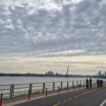
 Cycle along the Han River
- Distance
- 33 km
- Ascent
- 345 m
- Descent
- 335 m
- Location
- Goyang-si, Gyeonggi-do, South Korea
 13-21 13-21 ~ 문산읍 1254-2
- Distance
- 42.5 km
- Ascent
- 144 m
- Descent
- 176 m
- Location
- Goyang-si, Gyeonggi-do, South Korea
 흥도로70번길, 고양시에서 행신동, 고양시까지
- Distance
- 30.9 km
- Ascent
- 196 m
- Descent
- 184 m
- Location
- Goyang-si, Gyeonggi-do, South Korea
Open it in the app