

Von Dresden zum Kahleberg und zurück
A cycling route starting in Dresden, Saxony, Germany.
Overview
About this route
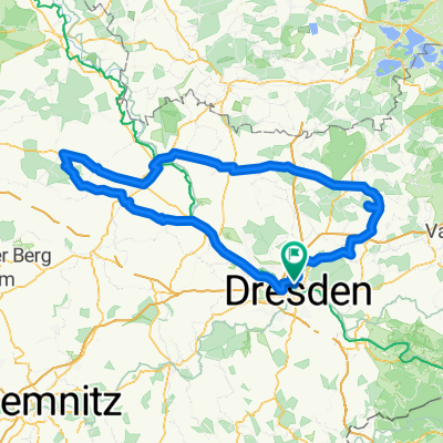
Die vorgestellte Radtour verbindet den Süden Dresdens (125 m NN) mit dem Kahleberg, den höchsten Gipfel des Osterzgebirges (9o4 m NN). Der untere Abschnitt führt durch den Lockwitzgrund von Dresden-Lockwitz bis zum Quellgebiet des Lockwitzbaches bei Oberfrauendorf (580 m NN). Der obere Abschnitt führt über sanfte Höhenzüge des Osterzgebirges bis zum Kahleberg bei der Altenberg. Die Route führt auf wenig befahrenen Kreisstraßen, einer autofreien Waldstraße sowie Forstwegen. Vor Altenberg muss man ca. 2 km auf der Bundesstraße B170 fahren bevor der Radweg erreicht ist. Die Rückfahrt nach Dresden kann alternativ über die Flusstäler von Wilder und Roter Weißeritz oder Müglitz geführt werden.
- -:--
- Duration
- 91.4 km
- Distance
- 1,154 m
- Ascent
- 1,157 m
- Descent
- ---
- Avg. speed
- ---
- Max. altitude
Route quality
Waytypes & surfaces along the route
Waytypes
Busy road
56.7 km
(62 %)
Track
15 km
(16 %)
Surfaces
Paved
77.9 km
(85 %)
Unpaved
6.6 km
(7 %)
Asphalt
73 km
(80 %)
Gravel
5 km
(5 %)
Continue with Bikemap
Use, edit, or download this cycling route
You would like to ride Von Dresden zum Kahleberg und zurück or customize it for your own trip? Here is what you can do with this Bikemap route:
Free features
- Save this route as favorite or in collections
- Copy & plan your own version of this route
- Split it into stages to create a multi-day tour
- Sync your route with Garmin or Wahoo
Premium features
Free trial for 3 days, or one-time payment. More about Bikemap Premium.
- Navigate this route on iOS & Android
- Export a GPX / KML file of this route
- Create your custom printout (try it for free)
- Download this route for offline navigation
Discover more Premium features.
Get Bikemap PremiumFrom our community
Other popular routes starting in Dresden
 Pre Velorace Trainingsausfahrt 2015 Einsteiger
- Distance
- 44.6 km
- Ascent
- 222 m
- Descent
- 222 m
- Location
- Dresden, Saxony, Germany
 Müglitztal - Königstein - Breitenau
- Distance
- 156 km
- Ascent
- 2,539 m
- Descent
- 2,398 m
- Location
- Dresden, Saxony, Germany
 Schmorsdorfer Höhenrunde
- Distance
- 49.8 km
- Ascent
- 510 m
- Descent
- 488 m
- Location
- Dresden, Saxony, Germany
 DD-Collm-Riesa-Keulenberg-DD
- Distance
- 196.8 km
- Ascent
- 1,000 m
- Descent
- 904 m
- Location
- Dresden, Saxony, Germany
 Dresden - Prag
- Distance
- 217.2 km
- Ascent
- 388 m
- Descent
- 303 m
- Location
- Dresden, Saxony, Germany
 Dresden - Altenberg
- Distance
- 52.7 km
- Ascent
- 1,016 m
- Descent
- 385 m
- Location
- Dresden, Saxony, Germany
 Dresden - Glashütte - Bahratal
- Distance
- 90.4 km
- Ascent
- 1,112 m
- Descent
- 1,142 m
- Location
- Dresden, Saxony, Germany
 cielab.org - Dresden - Bahratal - Mückentürmchen
- Distance
- 130 km
- Ascent
- 1,524 m
- Descent
- 1,516 m
- Location
- Dresden, Saxony, Germany
Open it in the app