

2022 Ruta Nº 086
A cycling route starting in Valladolid, Castille and León, Spain.
Overview
About this route
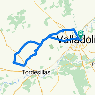
Pte Mayor -Villanubla -Wamba -Torrelobaton -San Pelayo -Castromonte -La Mudarra -Peñaflor -Wamba -Valladolid.
1st Climb: El Viso Avg. gradient 4.10% - Distance: 2.5 km
2nd Climb: Antanal Avg. gradient 3.00% Distance 4.0 Km.4
3rd Climb: El Reventón Avg. gradient 6.00% Distance 1.1 Km.
4th Climb: Carra Avg. gradient 5.90% Distance 1.1 Km
- -:--
- Duration
- 93.1 km
- Distance
- 577 m
- Ascent
- 576 m
- Descent
- ---
- Avg. speed
- 849 m
- Max. altitude

Route quality
Waytypes & surfaces along the route
Waytypes
Road
34.4 km
(37 %)
Quiet road
10.2 km
(11 %)
Surfaces
Paved
68.9 km
(74 %)
Unpaved
3.7 km
(4 %)
Asphalt
65.2 km
(70 %)
Paved (undefined)
1.9 km
(2 %)
Route highlights
Points of interest along the route
Point of interest after 8.6 km
1ª Subida: El Viso Pend.media 4,10% - Distancia: 2,5 km
Point of interest after 36.7 km
2º Subida: Antanal Pendiente media 3,00% Distancia 4,0 Km.
Point of interest after 64.2 km
3º Subida: El Reventón Pendiente media 6,00% Distancia 1,1 Km.
Point of interest after 73.9 km
4ª Subida: Carra Pendiente media 5,90% Distancia 1,1 Km
Continue with Bikemap
Use, edit, or download this cycling route
You would like to ride 2022 Ruta Nº 086 or customize it for your own trip? Here is what you can do with this Bikemap route:
Free features
- Save this route as favorite or in collections
- Copy & plan your own version of this route
- Split it into stages to create a multi-day tour
- Sync your route with Garmin or Wahoo
Premium features
Free trial for 3 days, or one-time payment. More about Bikemap Premium.
- Navigate this route on iOS & Android
- Export a GPX / KML file of this route
- Create your custom printout (try it for free)
- Download this route for offline navigation
Discover more Premium features.
Get Bikemap PremiumFrom our community
Other popular routes starting in Valladolid
 Circuito: VAREVITUCI
- Distance
- 37.6 km
- Ascent
- 303 m
- Descent
- 303 m
- Location
- Valladolid, Castille and León, Spain
 Circuito: (Parameño Valladolid)
- Distance
- 37.2 km
- Ascent
- 254 m
- Descent
- 257 m
- Location
- Valladolid, Castille and León, Spain
 Orilla Rio
- Distance
- 40.3 km
- Ascent
- 115 m
- Descent
- 115 m
- Location
- Valladolid, Castille and León, Spain
 vueltecilla mtb
- Distance
- 21.9 km
- Ascent
- 168 m
- Descent
- 159 m
- Location
- Valladolid, Castille and León, Spain
 2022 - Ruta nº 073
- Distance
- 101.3 km
- Ascent
- 730 m
- Descent
- 732 m
- Location
- Valladolid, Castille and León, Spain
 Ruta: 20-Mayo-2018 - (PM - Amistad)
- Distance
- 92.8 km
- Ascent
- 435 m
- Descent
- 431 m
- Location
- Valladolid, Castille and León, Spain
 Circuito: (Casasola Valladolid)
- Distance
- 14.2 km
- Ascent
- 47 m
- Descent
- 46 m
- Location
- Valladolid, Castille and León, Spain
 2022 - Ruta nº 051
- Distance
- 113.5 km
- Ascent
- 833 m
- Descent
- 829 m
- Location
- Valladolid, Castille and León, Spain
Open it in the app