Lorch nach Flugplatz Eibinger Forstwiesen
A cycling route starting in Niederheimbach, Rhineland-Palatinate, Germany.
Overview
About this route
Strecke führt zur im Norden des Flugplatzes gelegene Seilwinde
Specials:
-
ca. 400hm
-
ca. 1,5h Fahrt
-
kein normaler Straßenverkehr
VORSICHT: Bei Flugbetrieb auf dem Flugplatz (meist Wochenende)
- -:--
- Duration
- 9.2 km
- Distance
- 541 m
- Ascent
- 137 m
- Descent
- ---
- Avg. speed
- ---
- Avg. speed
Route quality
Waytypes & surfaces along the route
Waytypes
Track
7.6 km
(83 %)
Quiet road
0.6 km
(7 %)
Surfaces
Paved
2.6 km
(28 %)
Unpaved
6.4 km
(69 %)
Gravel
6.1 km
(67 %)
Asphalt
1.3 km
(14 %)
Continue with Bikemap
Use, edit, or download this cycling route
You would like to ride Lorch nach Flugplatz Eibinger Forstwiesen or customize it for your own trip? Here is what you can do with this Bikemap route:
Free features
- Save this route as favorite or in collections
- Copy & plan your own version of this route
- Sync your route with Garmin or Wahoo
Premium features
Free trial for 3 days, or one-time payment. More about Bikemap Premium.
- Navigate this route on iOS & Android
- Export a GPX / KML file of this route
- Create your custom printout (try it for free)
- Download this route for offline navigation
Discover more Premium features.
Get Bikemap PremiumFrom our community
Other popular routes starting in Niederheimbach
- 20090817 - Teil 2 - Niederheimbach - Koblenz - Kobern
- Distance
- 74.9 km
- Ascent
- 530 m
- Descent
- 547 m
- Location
- Niederheimbach, Rhineland-Palatinate, Germany
- Tag 5 Lorch - Koblenz
- Distance
- 52.3 km
- Ascent
- 294 m
- Descent
- 307 m
- Location
- Niederheimbach, Rhineland-Palatinate, Germany
- Lorch to Köln (Germany)
- Distance
- 144.9 km
- Ascent
- 92 m
- Descent
- 127 m
- Location
- Niederheimbach, Rhineland-Palatinate, Germany
- Rhein_2023_30
- Distance
- 30.1 km
- Ascent
- 139 m
- Descent
- 142 m
- Location
- Niederheimbach, Rhineland-Palatinate, Germany
- Lorch nach Flugplatz Eibinger Forstwiesen
- Distance
- 9.2 km
- Ascent
- 541 m
- Descent
- 137 m
- Location
- Niederheimbach, Rhineland-Palatinate, Germany
- Ren - Day 2
- Distance
- 59.8 km
- Ascent
- 96 m
- Descent
- 109 m
- Location
- Niederheimbach, Rhineland-Palatinate, Germany
- Binger Weg 13, Lorch nach Binger Weg 13, Lorch
- Distance
- 58.5 km
- Ascent
- 1,854 m
- Descent
- 1,854 m
- Location
- Niederheimbach, Rhineland-Palatinate, Germany
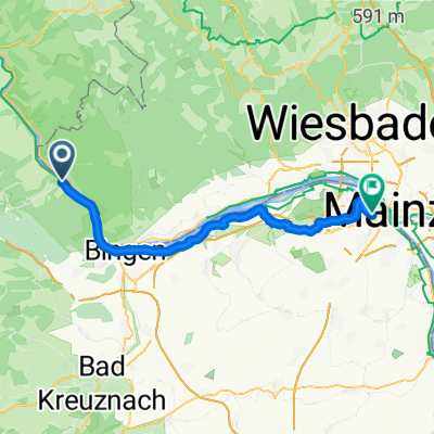
- Trainingsroute MTB Marathon
- Distance
- 20.1 km
- Ascent
- 521 m
- Descent
- 509 m
- Location
- Niederheimbach, Rhineland-Palatinate, Germany
Open it in the app