

Lichtenfels-Triebsdorf-Lichtenfels
A cycling route starting in Lichtenfels, Bavaria, Germany.
Overview
About this route
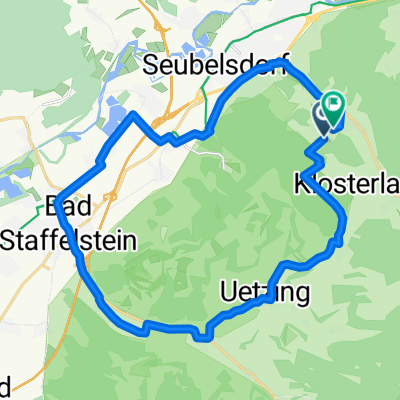
Schöne Sonntagsrund mit ein/zwei knackigen Anstiegen.Startpunkt Lichtenfels.Nach Kösten und an der Werdenfelser Hütte vorbei Richtung Buch am Forst.Nach der Brücke über die A73 links abbiegen und über Birkach und dem Wasserschloß Untersiemau nach Scherneck.Über Stöppach/Haarth nach Niederfüllbach.An der Kläranlage links den Berg hinauf zur ICE-Strecke.Über Forstwege zum Stegner Brunnen.Die Unterführung durch die A73 nehmen und Richtung Schifferbrunnen fahren.Zur Kreisstraße LIF 27 zurück und nach ca.100 mtr. den Radweg zur "Alten Coburger Straße" nehmen.Am Minigolf vorbei zur Stadtmitte.Der Weg ist so 50/50 Asphalt und Schotter.An einigen Stellen kann man ,wenn man will, aber auch auf unbefestigten Waldwegen fahren.
- -:--
- Duration
- 37.4 km
- Distance
- 429 m
- Ascent
- 430 m
- Descent
- ---
- Avg. speed
- ---
- Max. altitude

Route photos


Route quality
Waytypes & surfaces along the route
Waytypes
Track
17.9 km
(48 %)
Quiet road
9.3 km
(25 %)
Surfaces
Paved
14.9 km
(40 %)
Unpaved
16.1 km
(43 %)
Gravel
14.6 km
(39 %)
Asphalt
11.2 km
(30 %)
Continue with Bikemap
Use, edit, or download this cycling route
You would like to ride Lichtenfels-Triebsdorf-Lichtenfels or customize it for your own trip? Here is what you can do with this Bikemap route:
Free features
- Save this route as favorite or in collections
- Copy & plan your own version of this route
- Sync your route with Garmin or Wahoo
Premium features
Free trial for 3 days, or one-time payment. More about Bikemap Premium.
- Navigate this route on iOS & Android
- Export a GPX / KML file of this route
- Create your custom printout (try it for free)
- Download this route for offline navigation
Discover more Premium features.
Get Bikemap PremiumFrom our community
Other popular routes starting in Lichtenfels
 Lichtenfels nach Bamberg
- Distance
- 38.3 km
- Ascent
- 35 m
- Descent
- 62 m
- Location
- Lichtenfels, Bavaria, Germany
 Jakobusweg LIF-BA-FO-N
- Distance
- 72.8 km
- Ascent
- 951 m
- Descent
- 960 m
- Location
- Lichtenfels, Bavaria, Germany
 lichtenfels-bamberg
- Distance
- 38.3 km
- Ascent
- 62 m
- Descent
- 115 m
- Location
- Lichtenfels, Bavaria, Germany
 11.07.24 Coburg-Sand am Main (7. Etappe)
- Distance
- 87 km
- Ascent
- 329 m
- Descent
- 355 m
- Location
- Lichtenfels, Bavaria, Germany
 test1
test1- Distance
- 16 km
- Ascent
- 232 m
- Descent
- 143 m
- Location
- Lichtenfels, Bavaria, Germany
 Oberlangheim Stublang Reundorf
- Distance
- 25.7 km
- Ascent
- 286 m
- Descent
- 286 m
- Location
- Lichtenfels, Bavaria, Germany
 Lichtenfels - 2 Klöster (Staffelberg, 14 Hlg. , Banz) nach Coburg
- Distance
- 45.8 km
- Ascent
- 630 m
- Descent
- 602 m
- Location
- Lichtenfels, Bavaria, Germany
 Německo 2012-4.den-Main-Radweg
- Distance
- 68.4 km
- Ascent
- 163 m
- Descent
- 209 m
- Location
- Lichtenfels, Bavaria, Germany
Open it in the app