

Trans_Bayerwald_Sd_Etappe_4_Falkenstein_-_Sankt_Englmar
A cycling route starting in Falkenstein, Bavaria, Germany.
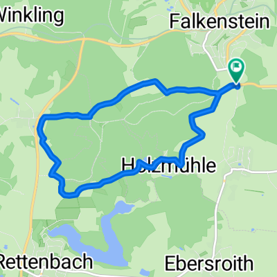
Overview
About this route
Diese GPS-Daten sind Eigentum des Projektes geo-coaching und ausschliesslich zur privaten Verwendung besimmt. Eine kommerzielle Verwendung ist ohne Genehmigung nicht gestattet.
- 3 h 19 min
- Duration
- 42.3 km
- Distance
- 1,588 m
- Ascent
- 1,253 m
- Descent
- 12.7 km/h
- Avg. speed
- ---
- Max. altitude
Route quality
Waytypes & surfaces along the route
Waytypes
Quiet road
17.3 km
(41 %)
Track
16.1 km
(38 %)
Surfaces
Paved
8.9 km
(21 %)
Unpaved
14.4 km
(34 %)
Asphalt
8 km
(19 %)
Ground
6.3 km
(15 %)
Continue with Bikemap
Use, edit, or download this cycling route
You would like to ride Trans_Bayerwald_Sd_Etappe_4_Falkenstein_-_Sankt_Englmar or customize it for your own trip? Here is what you can do with this Bikemap route:
Free features
- Save this route as favorite or in collections
- Copy & plan your own version of this route
- Sync your route with Garmin or Wahoo
Premium features
Free trial for 3 days, or one-time payment. More about Bikemap Premium.
- Navigate this route on iOS & Android
- Export a GPX / KML file of this route
- Create your custom printout (try it for free)
- Download this route for offline navigation
Discover more Premium features.
Get Bikemap PremiumFrom our community
Other popular routes starting in Falkenstein
 Falkenstein-Radweg CLONED FROM ROUTE 149000
- Distance
- 48.5 km
- Ascent
- 331 m
- Descent
- 559 m
- Location
- Falkenstein, Bavaria, Germany
 Von Falkenstein, über Regensburg nach Bach an der Donau
- Distance
- 52.6 km
- Ascent
- 120 m
- Descent
- 387 m
- Location
- Falkenstein, Bavaria, Germany
 Falkenstein Zinzendorf
- Distance
- 19.7 km
- Ascent
- 172 m
- Descent
- 464 m
- Location
- Falkenstein, Bavaria, Germany
 ACHAT - R 01 Neu - BY 4.11 - Falkenstein - Regensburg Dom
- Distance
- 48.1 km
- Ascent
- 207 m
- Descent
- 427 m
- Location
- Falkenstein, Bavaria, Germany
 Gonnersdorf - Falkenstein
- Distance
- 38.7 km
- Ascent
- 151 m
- Descent
- 420 m
- Location
- Falkenstein, Bavaria, Germany
 Trans_Bayerwald_Sd_Etappe_4_Falkenstein_-_Sankt_Englmar
- Distance
- 42.3 km
- Ascent
- 1,588 m
- Descent
- 1,253 m
- Location
- Falkenstein, Bavaria, Germany
 haselbach-michelsneukirchen-cham-haselbach
- Distance
- 90.8 km
- Ascent
- 734 m
- Descent
- 732 m
- Location
- Falkenstein, Bavaria, Germany
 Falkenstein Loipe
- Distance
- 7.4 km
- Ascent
- 134 m
- Descent
- 134 m
- Location
- Falkenstein, Bavaria, Germany
Open it in the app