

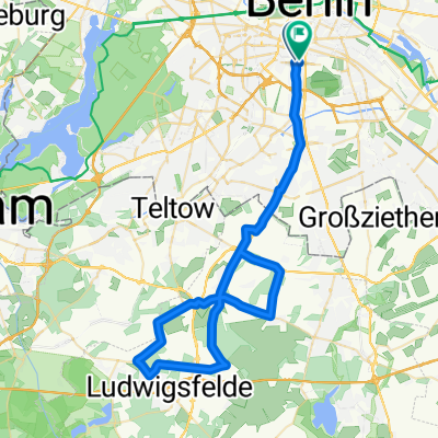
Wilhelm-Kabus-Straße 4, Berlin nach Sonnenblumenweg 49A, Glienicke/Nordbahn
A cycling route starting in Berlin Schöneberg, State of Berlin, Germany.
Overview
About this route
- 1 h 17 min
- Duration
- 21.8 km
- Distance
- 135 m
- Ascent
- 129 m
- Descent
- 16.9 km/h
- Avg. speed
- ---
- Max. altitude
Route quality
Waytypes & surfaces along the route
Waytypes
Quiet road
8.7 km
(40 %)
Pedestrian area
3 km
(14 %)
Surfaces
Paved
18.7 km
(86 %)
Unpaved
0.2 km
(1 %)
Asphalt
17.6 km
(81 %)
Concrete
0.7 km
(3 %)
Continue with Bikemap
Use, edit, or download this cycling route
You would like to ride Wilhelm-Kabus-Straße 4, Berlin nach Sonnenblumenweg 49A, Glienicke/Nordbahn or customize it for your own trip? Here is what you can do with this Bikemap route:
Free features
- Save this route as favorite or in collections
- Copy & plan your own version of this route
- Sync your route with Garmin or Wahoo
Premium features
Free trial for 3 days, or one-time payment. More about Bikemap Premium.
- Navigate this route on iOS & Android
- Export a GPX / KML file of this route
- Create your custom printout (try it for free)
- Download this route for offline navigation
Discover more Premium features.
Get Bikemap PremiumFrom our community
Other popular routes starting in Berlin Schöneberg
 Spreecity
- Distance
- 17.6 km
- Ascent
- 61 m
- Descent
- 62 m
- Location
- Berlin Schöneberg, State of Berlin, Germany
 Grunewald lap
- Distance
- 36.7 km
- Ascent
- 146 m
- Descent
- 142 m
- Location
- Berlin Schöneberg, State of Berlin, Germany
 Schöneberg --> Havelschleife
- Distance
- 75.8 km
- Ascent
- 298 m
- Descent
- 295 m
- Location
- Berlin Schöneberg, State of Berlin, Germany
 Kurze morgendliche Tainingsrunde für die Woche
- Distance
- 58.4 km
- Ascent
- 78 m
- Descent
- 87 m
- Location
- Berlin Schöneberg, State of Berlin, Germany
 Feierabendrunde Süd
- Distance
- 57.9 km
- Ascent
- 81 m
- Descent
- 84 m
- Location
- Berlin Schöneberg, State of Berlin, Germany
 Schöneberg-Tiergarten Runde
- Distance
- 18.9 km
- Ascent
- 37 m
- Descent
- 41 m
- Location
- Berlin Schöneberg, State of Berlin, Germany
 Radwegetest Berlin-Kopenh. / Oder-Havel / Usedom
- Distance
- 140.2 km
- Ascent
- 306 m
- Descent
- 299 m
- Location
- Berlin Schöneberg, State of Berlin, Germany
 Beelitz
- Distance
- 97.5 km
- Ascent
- 153 m
- Descent
- 152 m
- Location
- Berlin Schöneberg, State of Berlin, Germany
Open it in the app