

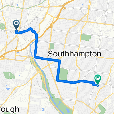
6802 Hancock Ave, St. Louis to 6802 Hancock Ave, St. Louis
A cycling route starting in Maplewood, Missouri, United States.
Overview
About this route
- 1 h 4 min
- Duration
- 20.1 km
- Distance
- 161 m
- Ascent
- 159 m
- Descent
- 18.8 km/h
- Avg. speed
- ---
- Max. altitude
Route photos

Continue with Bikemap
Use, edit, or download this cycling route
You would like to ride 6802 Hancock Ave, St. Louis to 6802 Hancock Ave, St. Louis or customize it for your own trip? Here is what you can do with this Bikemap route:
Free features
- Save this route as favorite or in collections
- Copy & plan your own version of this route
- Sync your route with Garmin or Wahoo
Premium features
Free trial for 3 days, or one-time payment. More about Bikemap Premium.
- Navigate this route on iOS & Android
- Export a GPX / KML file of this route
- Create your custom printout (try it for free)
- Download this route for offline navigation
Discover more Premium features.
Get Bikemap PremiumFrom our community
Other popular routes starting in Maplewood
 3140 Harlequin Ln, St. Louis to 11 Zinzer Ct, Grantwood Village
- Distance
- 10 km
- Ascent
- 92 m
- Descent
- 108 m
- Location
- Maplewood, Missouri, United States
 6802 Hancock Ave, St. Louis to 6802 Hancock Ave, St. Louis
- Distance
- 20.1 km
- Ascent
- 161 m
- Descent
- 159 m
- Location
- Maplewood, Missouri, United States
 Grants Trail – Giant Loop
- Distance
- 42.6 km
- Ascent
- 353 m
- Descent
- 355 m
- Location
- Maplewood, Missouri, United States
 Recovered Route
- Distance
- 2.1 km
- Ascent
- 13 m
- Descent
- 30 m
- Location
- Maplewood, Missouri, United States
 shaw tennis park
- Distance
- 5.7 km
- Ascent
- 67 m
- Descent
- 51 m
- Location
- Maplewood, Missouri, United States
 2303 Bellevue Ave, Maplewood a 2307 Bellevue Ave, Maplewood
- Distance
- 17.8 km
- Ascent
- 147 m
- Descent
- 149 m
- Location
- Maplewood, Missouri, United States
 Laclede Station Road 3226, Maplewood to Rosa Avenue 5137, St. Louis
- Distance
- 6.4 km
- Ascent
- 0 m
- Descent
- 9 m
- Location
- Maplewood, Missouri, United States
 back home
- Distance
- 5.4 km
- Ascent
- 0 m
- Descent
- 0 m
- Location
- Maplewood, Missouri, United States
Open it in the app