

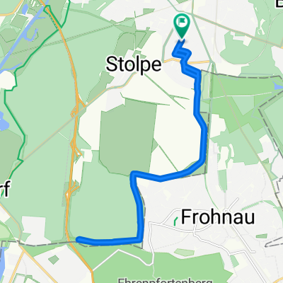
HoNeu-Schönow
A cycling route starting in Hohen Neuendorf, Brandenburg, Germany.
Overview
About this route
All types of paths included. The route is diverse and can be completed in 2.5 hours.
- -:--
- Duration
- 46.9 km
- Distance
- 136 m
- Ascent
- 137 m
- Descent
- ---
- Avg. speed
- ---
- Max. altitude

Continue with Bikemap
Use, edit, or download this cycling route
You would like to ride HoNeu-Schönow or customize it for your own trip? Here is what you can do with this Bikemap route:
Free features
- Save this route as favorite or in collections
- Copy & plan your own version of this route
- Sync your route with Garmin or Wahoo
Premium features
Free trial for 3 days, or one-time payment. More about Bikemap Premium.
- Navigate this route on iOS & Android
- Export a GPX / KML file of this route
- Create your custom printout (try it for free)
- Download this route for offline navigation
Discover more Premium features.
Get Bikemap PremiumFrom our community
Other popular routes starting in Hohen Neuendorf
 Feierabendrunde Hohen Neuendorf - Tegler Fließ - Hohen Neuendorf
- Distance
- 25.3 km
- Ascent
- 90 m
- Descent
- 92 m
- Location
- Hohen Neuendorf, Brandenburg, Germany
 HoNeu-Wensickendorf-Zehlendorf-Friedrichsthal-Lehnitzsee-Borgsdorf-HoNeu
- Distance
- 47.3 km
- Ascent
- 97 m
- Descent
- 97 m
- Location
- Hohen Neuendorf, Brandenburg, Germany
 mauerweg (Asphalt)
- Distance
- 15.1 km
- Ascent
- 124 m
- Descent
- 163 m
- Location
- Hohen Neuendorf, Brandenburg, Germany
 17 Berlin-Warendorf
- Distance
- 546.8 km
- Ascent
- 203 m
- Descent
- 205 m
- Location
- Hohen Neuendorf, Brandenburg, Germany
 Von Bergfelde nach Pritzerbe
- Distance
- 77.3 km
- Ascent
- 120 m
- Descent
- 153 m
- Location
- Hohen Neuendorf, Brandenburg, Germany
 240km_HND_Schorfh_Uckermark_HND
- Distance
- 241 km
- Ascent
- 228 m
- Descent
- 228 m
- Location
- Hohen Neuendorf, Brandenburg, Germany
 Jacob-Wins-Straße 17, Hohen Neuendorf nach Jacob-Wins-Straße 17, Hohen Neuendorf
- Distance
- 19.3 km
- Ascent
- 103 m
- Descent
- 108 m
- Location
- Hohen Neuendorf, Brandenburg, Germany
 Unbenannte Route
- Distance
- 504.1 km
- Ascent
- 1,753 m
- Descent
- 1,800 m
- Location
- Hohen Neuendorf, Brandenburg, Germany
Open it in the app