

Montargis-Auxerre
A cycling route starting in Châlette-sur-Loing, Centre-Val de Loire, France.
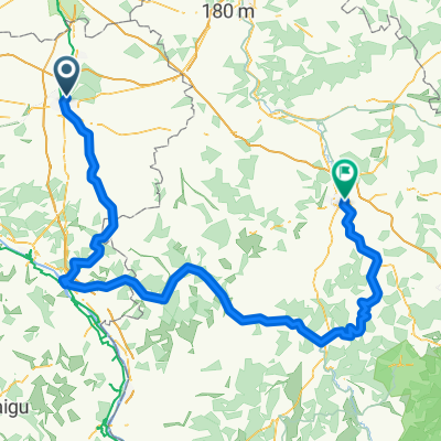
Overview
About this route
Canal de Briare Puisaye Canal du Nivernais 23/24 October 2010
- -:--
- Duration
- 192.1 km
- Distance
- 346 m
- Ascent
- 330 m
- Descent
- ---
- Avg. speed
- ---
- Max. altitude

Route highlights
Points of interest along the route
Point of interest after 33.2 km
Les 7 écluses, impressionnante échelle d'écluses maintenant désaffectées.
Point of interest after 41 km
Pique-nique Froid, venteux et du coup rapide !
Point of interest after 45.8 km
ça monte raide dans le village !
Point of interest after 49.4 km
Détour sans grand intérêt en suivant le jalonnement cyclable ...
Point of interest after 56.3 km
Le pont-canal de Briare.
Point of interest after 74.6 km
Quasiment 20km de route sans personne dans de belles hêtraies.
Point of interest after 90.9 km
Saint-Fargeau, joli centre et imposant château
Point of interest after 95.8 km
Hôtel le Saint-Fiacre. Gastronomique !
Point of interest after 112.2 km
Point le plus haut du parcours. 303m d'altitude. Après ça descend !
Point of interest after 113.5 km
Par ici il semblerait qu'on puisse bifurquer vers la Entrain et la Loire
Point of interest after 127.6 km
Château fort dominant le village. On a eu la flemme d'y monter.
Point of interest after 138.3 km
On rejoint le jalonnement du canal du Nivernais
Point of interest after 156.3 km
Belles falaises pour les amateurs d'ecalade
Point of interest after 191.3 km
Voie verte avec accès merdiques pour les vélos. Encore un truc pour cycliste fait par des gens qui n'ont jamais fait de vélo. Au moins ça permet de rejoindre la gare rapidement.
Continue with Bikemap
Use, edit, or download this cycling route
You would like to ride Montargis-Auxerre or customize it for your own trip? Here is what you can do with this Bikemap route:
Free features
- Save this route as favorite or in collections
- Copy & plan your own version of this route
- Split it into stages to create a multi-day tour
- Sync your route with Garmin or Wahoo
Premium features
Free trial for 3 days, or one-time payment. More about Bikemap Premium.
- Navigate this route on iOS & Android
- Export a GPX / KML file of this route
- Create your custom printout (try it for free)
- Download this route for offline navigation
Discover more Premium features.
Get Bikemap PremiumFrom our community
Other popular routes starting in Châlette-sur-Loing
 Châlette sur Loing - Paris - PFixe
- Distance
- 95.6 km
- Ascent
- 217 m
- Descent
- 234 m
- Location
- Châlette-sur-Loing, Centre-Val de Loire, France
 Montargis-Auxerre
- Distance
- 192.1 km
- Ascent
- 346 m
- Descent
- 330 m
- Location
- Châlette-sur-Loing, Centre-Val de Loire, France
 Ride Chalette sur Loing - PFixe
- Distance
- 43.5 km
- Ascent
- 41 m
- Descent
- 40 m
- Location
- Châlette-sur-Loing, Centre-Val de Loire, France
 Recovered Route
- Distance
- 5.2 km
- Ascent
- 21 m
- Descent
- 19 m
- Location
- Châlette-sur-Loing, Centre-Val de Loire, France
 Ride Châlette sur Loing - Souppes sur Loing - PFixe
- Distance
- 53.9 km
- Ascent
- 163 m
- Descent
- 160 m
- Location
- Châlette-sur-Loing, Centre-Val de Loire, France
 4 Avenue de la Gare, Montargis à 2 Rue Bourgogne, Douchy
- Distance
- 27.8 km
- Ascent
- 92 m
- Descent
- 52 m
- Location
- Châlette-sur-Loing, Centre-Val de Loire, France
 Tour de France 2018 / Stage 21 / Montargis-Champs-Elysées
- Distance
- 128 km
- Ascent
- 304 m
- Descent
- 323 m
- Location
- Châlette-sur-Loing, Centre-Val de Loire, France
 De 136 Rue Gambetta, Châlette-sur-Loing à 13 Route de la Fontaine Brochet, Chevillon-sur-Huillard
- Distance
- 8.9 km
- Ascent
- 30 m
- Descent
- 26 m
- Location
- Châlette-sur-Loing, Centre-Val de Loire, France
Open it in the app