

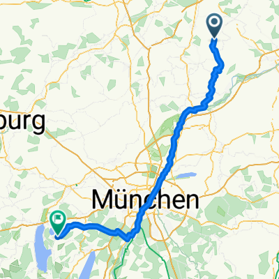
Radl Tour
A cycling route starting in Volkenschwand, Bavaria, Germany.
Overview
About this route
- -:--
- Duration
- 113.7 km
- Distance
- 414 m
- Ascent
- 335 m
- Descent
- ---
- Avg. speed
- ---
- Avg. speed
Route quality
Waytypes & surfaces along the route
Waytypes
Track
28.5 km
(25 %)
Cycleway
21.6 km
(19 %)
Surfaces
Paved
66.3 km
(58 %)
Unpaved
45.5 km
(40 %)
Asphalt
65.2 km
(57 %)
Gravel
25.1 km
(22 %)
Continue with Bikemap
Use, edit, or download this cycling route
You would like to ride Radl Tour or customize it for your own trip? Here is what you can do with this Bikemap route:
Free features
- Save this route as favorite or in collections
- Copy & plan your own version of this route
- Split it into stages to create a multi-day tour
- Sync your route with Garmin or Wahoo
Premium features
Free trial for 3 days, or one-time payment. More about Bikemap Premium.
- Navigate this route on iOS & Android
- Export a GPX / KML file of this route
- Create your custom printout (try it for free)
- Download this route for offline navigation
Discover more Premium features.
Get Bikemap PremiumFrom our community
Other popular routes starting in Volkenschwand
 Radl Tour
- Distance
- 113.7 km
- Ascent
- 414 m
- Descent
- 335 m
- Location
- Volkenschwand, Bavaria, Germany
 Rundfahrt zum Fernmeldeturm Dirnberg
- Distance
- 27.5 km
- Ascent
- 165 m
- Descent
- 165 m
- Location
- Volkenschwand, Bavaria, Germany
 Schlott 9, Volkenschwand to Bogenbergerstraße 15A, Mainburg
- Distance
- 9.4 km
- Ascent
- 92 m
- Descent
- 167 m
- Location
- Volkenschwand, Bavaria, Germany
 Dietrichsdorf, Volkenschwand nach Dietrichsdorf, Volkenschwand
- Distance
- 32.7 km
- Ascent
- 249 m
- Descent
- 249 m
- Location
- Volkenschwand, Bavaria, Germany
 Großer Laaberradweg
- Distance
- 87.5 km
- Ascent
- 40 m
- Descent
- 185 m
- Location
- Volkenschwand, Bavaria, Germany
 Dietrichsdorf, Volkenschwand nach Dietrichsdorf, Volkenschwand
- Distance
- 8.3 km
- Ascent
- 54 m
- Descent
- 58 m
- Location
- Volkenschwand, Bavaria, Germany
 Große Laaber Radweg
- Distance
- 86.5 km
- Ascent
- 60 m
- Descent
- 221 m
- Location
- Volkenschwand, Bavaria, Germany
 Volkenschwand Umgebung
- Distance
- 24.3 km
- Ascent
- 159 m
- Descent
- 159 m
- Location
- Volkenschwand, Bavaria, Germany
Open it in the app