
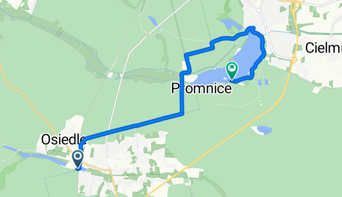
Trasa z Leśników, Kobiór
A cycling route starting in Kobiór, Silesian Voivodeship, Poland.
Overview
About this route
- 29 min
- Duration
- 9.9 km
- Distance
- 207 m
- Ascent
- 214 m
- Descent
- 20.7 km/h
- Avg. speed
- ---
- Max. altitude
Route quality
Waytypes & surfaces along the route
Waytypes
Access road
3.8 km
(39 %)
Path
2.4 km
(25 %)
Surfaces
Paved
5.7 km
(58 %)
Unpaved
1.9 km
(19 %)
Asphalt
4.2 km
(43 %)
Gravel
1.2 km
(13 %)
Continue with Bikemap
Use, edit, or download this cycling route
You would like to ride Trasa z Leśników, Kobiór or customize it for your own trip? Here is what you can do with this Bikemap route:
Free features
- Save this route as favorite or in collections
- Copy & plan your own version of this route
- Sync your route with Garmin or Wahoo
Premium features
Free trial for 3 days, or one-time payment. More about Bikemap Premium.
- Navigate this route on iOS & Android
- Export a GPX / KML file of this route
- Create your custom printout (try it for free)
- Download this route for offline navigation
Discover more Premium features.
Get Bikemap PremiumFrom our community
Other popular routes starting in Kobiór
 Jezioro Paprocańskie Zamek Myśliwski Promnice
- Distance
- 9.1 km
- Ascent
- 50 m
- Descent
- 51 m
- Location
- Kobiór, Silesian Voivodeship, Poland
 Kobiórska 8 do Kobiórska 8
- Distance
- 23.5 km
- Ascent
- 61 m
- Descent
- 64 m
- Location
- Kobiór, Silesian Voivodeship, Poland
 Kobiór, Paprocany, Zgoń, Kobiór
- Distance
- 45.3 km
- Ascent
- 297 m
- Descent
- 295 m
- Location
- Kobiór, Silesian Voivodeship, Poland
 lasy pszczynskie
- Distance
- 42.8 km
- Ascent
- 155 m
- Descent
- 158 m
- Location
- Kobiór, Silesian Voivodeship, Poland
 Leśników, Kobiór do Śląska, Katowice
- Distance
- 46.1 km
- Ascent
- 258 m
- Descent
- 228 m
- Location
- Kobiór, Silesian Voivodeship, Poland
 Paprocany- Goczałkowickie- Żywieckie 67km km
- Distance
- 155 km
- Ascent
- 410 m
- Descent
- 388 m
- Location
- Kobiór, Silesian Voivodeship, Poland
 Rezerwat Dobrzyna Dolina
- Distance
- 27.9 km
- Ascent
- 111 m
- Descent
- 111 m
- Location
- Kobiór, Silesian Voivodeship, Poland
 GUSTAWÓW v MAR
- Distance
- 214.1 km
- Ascent
- 437 m
- Descent
- 415 m
- Location
- Kobiór, Silesian Voivodeship, Poland
Open it in the app