Naturparkwanderweg(10000 Schritte)
- 7.1 km
- 178 m
- 178 m
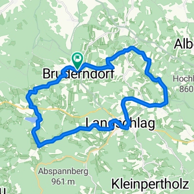
- Langschlag, Lower Austria, Austria
A cycling route starting in Langschlag, Lower Austria, Austria.
Overview
From the place, the tour leads past the castle towards the paper mill, where after a rapid asphalt descent, the branch into the Mill Path sharply turns right. This cart track takes us to Steinbach where we cross the B41 towards Mühlbach. Before the railway crossing, it goes left along the narrow-gauge railway towards Fasseldorf. A short asphalt climb takes us to Weikertschlag where we again head into the terrain towards Bruderndorf to a 'Biker Oasis'. Strengthened, we head towards the European Watershed where we then descend to cross the narrow-gauge railway track and continue on part of the Granittrail along the Kuckucksbach stream. Upon reaching the Stockmühle, there is one more steep asphalt ascent before we bike towards the goal.
created this 5 years ago
Route quality
Track
8.8 km
(62 %)
Road
3.6 km
(25 %)
Paved
1.1 km
(8 %)
Unpaved
8.4 km
(59 %)
Gravel
3.6 km
(25 %)
Unpaved (undefined)
2.6 km
(18 %)
Continue with Bikemap
You would like to ride Fassldorf-Neu or customize it for your own trip? Here is what you can do with this Bikemap route:
Free trial for 3 days, or one-time payment. More about Bikemap Premium.
Discover more Premium features.
Get Bikemap PremiumFrom our community
Open it in the app