

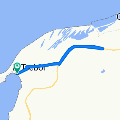
De Calle 14 1605, Eduardo Santos a Calle 78a 82449, Barranquilla
A cycling route starting in Puerto Colombia, Atlántico, Colombia.
Overview
About this route
- 1 h 46 min
- Duration
- 15.7 km
- Distance
- 155 m
- Ascent
- 191 m
- Descent
- 8.9 km/h
- Avg. speed
- ---
- Max. altitude

Route photos

Route quality
Waytypes & surfaces along the route
Waytypes
Cycleway
5.6 km
(36 %)
Road
4.2 km
(27 %)
Surfaces
Paved
11.1 km
(71 %)
Unpaved
0.2 km
(1 %)
Concrete
7.5 km
(48 %)
Asphalt
2.5 km
(16 %)
Continue with Bikemap
Use, edit, or download this cycling route
You would like to ride De Calle 14 1605, Eduardo Santos a Calle 78a 82449, Barranquilla or customize it for your own trip? Here is what you can do with this Bikemap route:
Free features
- Save this route as favorite or in collections
- Copy & plan your own version of this route
- Sync your route with Garmin or Wahoo
Premium features
Free trial for 3 days, or one-time payment. More about Bikemap Premium.
- Navigate this route on iOS & Android
- Export a GPX / KML file of this route
- Create your custom printout (try it for free)
- Download this route for offline navigation
Discover more Premium features.
Get Bikemap PremiumFrom our community
Other popular routes starting in Puerto Colombia
 De Puerto Colombia-Barranquilla a Calle 11b # 9-80
- Distance
- 46 km
- Ascent
- 380 m
- Descent
- 374 m
- Location
- Puerto Colombia, Atlántico, Colombia
 Barranquilla XXIII JC
- Distance
- 40 km
- Ascent
- ---
- Descent
- ---
- Location
- Puerto Colombia, Atlántico, Colombia
 Vía al Mar, Puerto Colombia a Vía al Mar, Puerto Colombia
- Distance
- 1 km
- Ascent
- 0 m
- Descent
- 3 m
- Location
- Puerto Colombia, Atlántico, Colombia
 TROCHITA
- Distance
- 11.6 km
- Ascent
- 211 m
- Descent
- 132 m
- Location
- Puerto Colombia, Atlántico, Colombia
 De Calle 14 1605, Eduardo Santos a Calle 78a 82449, Barranquilla
- Distance
- 15.7 km
- Ascent
- 155 m
- Descent
- 191 m
- Location
- Puerto Colombia, Atlántico, Colombia
 cel barranqui,
- Distance
- 40 km
- Ascent
- 351 m
- Descent
- 350 m
- Location
- Puerto Colombia, Atlántico, Colombia
 De Vía al Mar, Puerto Colombia a Carrera 49C 80-100–80-2, Barranquilla
- Distance
- 26.6 km
- Ascent
- 4 m
- Descent
- 11 m
- Location
- Puerto Colombia, Atlántico, Colombia
 CAMINATA EL MORRO - JUARUCO - CORRAL DE SAN LUIS - TUBARÁ
- Distance
- 13 km
- Ascent
- 494 m
- Descent
- 296 m
- Location
- Puerto Colombia, Atlántico, Colombia
Open it in the app