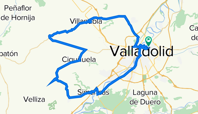
2021 - Ruta nº 116
A cycling route starting in Valladolid, Castille and León, Spain.
Overview
About this route
Pte,Mayor - Pso.Zorrilla - Ctra.vieja - Simancas - (Interior Pueblo) - Geria - Robladillo - Ciguñuela - Wamba - Villanubla - Fuensaldaña - Valladolid.
1º Subida: La Trampa (1) -
(Geria hacia Robladillo)
Pendiente media 4,80%
2ª Subida: Alto Paramillo -
(Robladillo hacia Ciguñuela)
Pendiente media 3,20%
Longitud: 3,5 Km.
3ª Repecho: Alto Ciguñuela -
(Ciguñuela)
Pendiente media- (no puntua)
Longitud: 1,2 Km.
- -:--
- Duration
- 64.7 km
- Distance
- 1,562 m
- Ascent
- 1,562 m
- Descent
- ---
- Avg. speed
- 845 m
- Max. altitude
Route quality
Waytypes & surfaces along the route
Waytypes
Road
39.5 km
(61 %)
Track
5.2 km
(8 %)
Surfaces
Paved
51.1 km
(79 %)
Unpaved
1.3 km
(2 %)
Asphalt
49.8 km
(77 %)
Unpaved (undefined)
1.3 km
(2 %)
Route highlights
Points of interest along the route
Point of interest after 21.7 km
1º Subida: La Trampa (1) - (Geria hacia Robladillo) Pendiente media 4,80%
Point of interest after 27 km
2ª Subida: Alto Paramillo - (Robladillo hacia Ciguñuela) Pendiente media 3,20% Longitud: 3,5 Km.
Point of interest after 31.6 km
3ª Repecho: Alto Ciguñuela - (Ciguñuela) Pendiente media- (no puntua) Longitud: 1,2 Km.
Continue with Bikemap
Use, edit, or download this cycling route
You would like to ride 2021 - Ruta nº 116 or customize it for your own trip? Here is what you can do with this Bikemap route:
Free features
- Save this route as favorite or in collections
- Copy & plan your own version of this route
- Sync your route with Garmin or Wahoo
Premium features
Free trial for 3 days, or one-time payment. More about Bikemap Premium.
- Navigate this route on iOS & Android
- Export a GPX / KML file of this route
- Create your custom printout (try it for free)
- Download this route for offline navigation
Discover more Premium features.
Get Bikemap PremiumFrom our community
Other popular routes starting in Valladolid
- Circuito: (Parameño Valladolid)
- Distance
- 37.2 km
- Ascent
- 254 m
- Descent
- 257 m
- Location
- Valladolid, Castille and León, Spain
- 2021 - Ruta nº 51
- Distance
- 84.5 km
- Ascent
- 390 m
- Descent
- 384 m
- Location
- Valladolid, Castille and León, Spain
- 2022 - Ruta nº 073
- Distance
- 98.2 km
- Ascent
- 439 m
- Descent
- 442 m
- Location
- Valladolid, Castille and León, Spain
- Ciguñuela
- Distance
- 16.3 km
- Ascent
- 200 m
- Descent
- 103 m
- Location
- Valladolid, Castille and León, Spain
- Orilla Rio
- Distance
- 40.3 km
- Ascent
- 115 m
- Descent
- 115 m
- Location
- Valladolid, Castille and León, Spain
- 2022 - Ruta nº 059
- Distance
- 130.1 km
- Ascent
- 733 m
- Descent
- 733 m
- Location
- Valladolid, Castille and León, Spain
- 2022 - Ruta nº 062
- Distance
- 118.5 km
- Ascent
- 683 m
- Descent
- 686 m
- Location
- Valladolid, Castille and León, Spain
- 2022 - Ruta nº 063
- Distance
- 100.1 km
- Ascent
- 201 m
- Descent
- 199 m
- Location
- Valladolid, Castille and León, Spain
Open it in the app