

Skierki around.
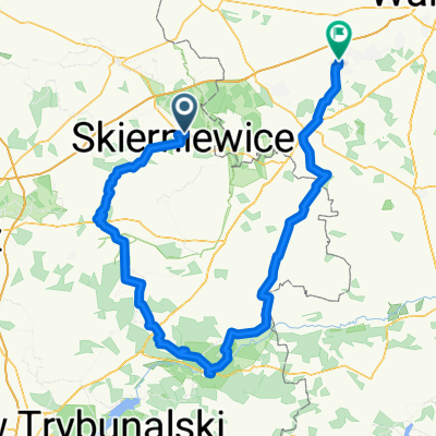
A cycling route starting in Skierniewice, Łódź Voivodeship, Poland.
Overview
About this route
- -:--
- Duration
- 100.3 km
- Distance
- 147 m
- Ascent
- 156 m
- Descent
- ---
- Avg. speed
- ---
- Max. altitude

Route quality
Waytypes & surfaces along the route
Waytypes
Quiet road
55.2 km
(55 %)
Road
30.2 km
(30 %)
Surfaces
Paved
65 km
(65 %)
Unpaved
8.5 km
(8 %)
Asphalt
56.9 km
(57 %)
Paving stones
7.1 km
(7 %)
Route highlights
Points of interest along the route
Point of interest after 64.1 km
Marcin
Continue with Bikemap
Use, edit, or download this cycling route
You would like to ride Skierki around. or customize it for your own trip? Here is what you can do with this Bikemap route:
Free features
- Save this route as favorite or in collections
- Copy & plan your own version of this route
- Split it into stages to create a multi-day tour
- Sync your route with Garmin or Wahoo
Premium features
Free trial for 3 days, or one-time payment. More about Bikemap Premium.
- Navigate this route on iOS & Android
- Export a GPX / KML file of this route
- Create your custom printout (try it for free)
- Download this route for offline navigation
Discover more Premium features.
Get Bikemap PremiumFrom our community
Other popular routes starting in Skierniewice
 Pierwsza czerwcowa niedziela
- Distance
- 41.2 km
- Ascent
- 43 m
- Descent
- 43 m
- Location
- Skierniewice, Łódź Voivodeship, Poland
 Tour de Baby
- Distance
- 103.2 km
- Ascent
- 234 m
- Descent
- 157 m
- Location
- Skierniewice, Łódź Voivodeship, Poland
 "Szlak Kultury Janisławickiej" (szlak rowerowy, zielony)
- Distance
- 56 km
- Ascent
- 249 m
- Descent
- 249 m
- Location
- Skierniewice, Łódź Voivodeship, Poland
 Skierki around.
- Distance
- 100.3 km
- Ascent
- 147 m
- Descent
- 156 m
- Location
- Skierniewice, Łódź Voivodeship, Poland
 Skierniewice Bolimów Zadębie
- Distance
- 68.2 km
- Ascent
- 66 m
- Descent
- 69 m
- Location
- Skierniewice, Łódź Voivodeship, Poland
 Rozpoczęcie sezonu 2013
- Distance
- 48.3 km
- Ascent
- 79 m
- Descent
- 76 m
- Location
- Skierniewice, Łódź Voivodeship, Poland
 Budy Grabskie 50B, Skierniewice to Budy Grabskie, Skierniewice
- Distance
- 68.7 km
- Ascent
- 229 m
- Descent
- 213 m
- Location
- Skierniewice, Łódź Voivodeship, Poland
 2014-03-29.30_Skierniewice - Bunkier w Konewce
- Distance
- 181.7 km
- Ascent
- 337 m
- Descent
- 356 m
- Location
- Skierniewice, Łódź Voivodeship, Poland
Open it in the app