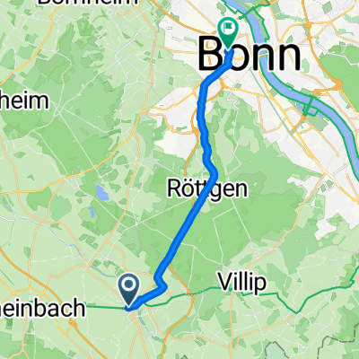
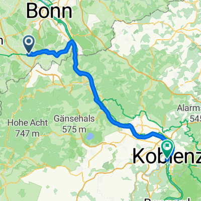
Kottenforst-Ville
A cycling route starting in Meckenheim, North Rhine-Westphalia, Germany.
Overview
About this route
Kottenforst-Ville
- -:--
- Duration
- 62.3 km
- Distance
- 106 m
- Ascent
- 227 m
- Descent
- ---
- Avg. speed
- ---
- Max. altitude
Route quality
Waytypes & surfaces along the route
Waytypes
Quiet road
21.7 km
(35 %)
Track
17.7 km
(28 %)
Surfaces
Paved
44.8 km
(72 %)
Unpaved
13 km
(21 %)
Asphalt
35.3 km
(57 %)
Pebblestone
8.5 km
(14 %)
Route highlights
Points of interest along the route
Point of interest after 6.7 km
Waldgaststätte Bahnhof Kottenforst Inh. Sonja & Tobias Selz GbR Bahnhof Kottenforst 8 53340 Meckenheim Telefon: 02225-7322
Continue with Bikemap
Use, edit, or download this cycling route
You would like to ride Kottenforst-Ville or customize it for your own trip? Here is what you can do with this Bikemap route:
Free features
- Save this route as favorite or in collections
- Copy & plan your own version of this route
- Sync your route with Garmin or Wahoo
Premium features
Free trial for 3 days, or one-time payment. More about Bikemap Premium.
- Navigate this route on iOS & Android
- Export a GPX / KML file of this route
- Create your custom printout (try it for free)
- Download this route for offline navigation
Discover more Premium features.
Get Bikemap PremiumFrom our community
Other popular routes starting in Meckenheim
- Am Rebstock 11, Meckenheim nach Am Rebstock 22, Meckenheim
- Distance
- 14.2 km
- Ascent
- 86 m
- Descent
- 95 m
- Location
- Meckenheim, North Rhine-Westphalia, Germany
- Rheintal: Wine, Rhine and Romans
- Distance
- 266.2 km
- Ascent
- 6,602 m
- Descent
- 6,603 m
- Location
- Meckenheim, North Rhine-Westphalia, Germany
- Kottenforst-Ville
- Distance
- 62.3 km
- Ascent
- 106 m
- Descent
- 227 m
- Location
- Meckenheim, North Rhine-Westphalia, Germany
- Dechant-Kreiten-Straße 14, Meckenheim nach Keramikerstraße 61, Rheinbach
- Distance
- 6.5 km
- Ascent
- 18 m
- Descent
- 20 m
- Location
- Meckenheim, North Rhine-Westphalia, Germany
- Small round south of Bonn, Germany
- Distance
- 58.4 km
- Ascent
- 300 m
- Descent
- 290 m
- Location
- Meckenheim, North Rhine-Westphalia, Germany
- Trainingsrunde Meckem-Pech-Berkum
- Distance
- 44 km
- Ascent
- 485 m
- Descent
- 485 m
- Location
- Meckenheim, North Rhine-Westphalia, Germany
- Meckenheim - Rech
- Distance
- 44.7 km
- Ascent
- 760 m
- Descent
- 760 m
- Location
- Meckenheim, North Rhine-Westphalia, Germany
- vom Kottenforst zum Königsforst
- Distance
- 64.6 km
- Ascent
- 173 m
- Descent
- 286 m
- Location
- Meckenheim, North Rhine-Westphalia, Germany
Open it in the app