2019 C2C
- 219.4 km
- 1,613 m
- 1,611 m
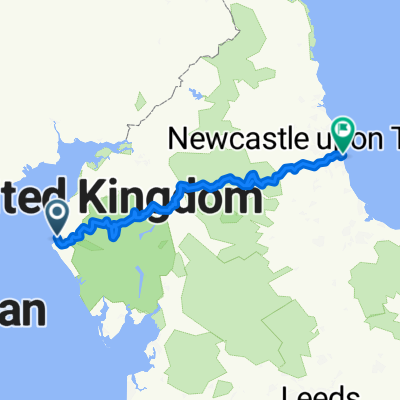
- Whitehaven, England, United Kingdom
A cycling route starting in Whitehaven, England, United Kingdom.
Overview
<span style="font-family: Arial,sans-serif;">This is my C2C route I created for my road touring bike 3 day trip from Whitehaven to Sunderland prepared for May 2011. I converted the gpx file to a tcx file for my Garmin. Having ridden my tcx track, I am not aware of any significant errors. I have also included my cycling directions which I prepared should my Garmin 705 not work.</span>
My overnight stops were at Kirkoswald and Rookhope. I have not followed the published C2C route exactly. From Kirkland I have avoided a small climb towards Murton Fell but instead cycle for about 0.4 miles on the A5086. Choosing to stay overnight in Kirkoswald, it made sense to by-pass Penrith. The most significant off road section that I have included is the incline out of Rookhope to avoid the Crawleyside climb. I rode my 1980s HoIdswoth Mistral to which I've added low gearing and strong Rigida Snyper 700c wheels. I mostly walked up the Rookhope incline, the path was too rough, me too slow and the rocks to wet from the drizzle. After reaching the top of the Rookhope Incline, I cycled on the C2C path for a further 1.6 miles then turned left and walked up a rough path for 430yds to acces a tarmac road.
Here are my cycling directions. I have checked for errors but as I mainly used my Garmin gps, some may still exist which I have not yet spotted. The formatting seems to have changed in the cut and paste process.
<span style="font-family: Arial,sans-serif;"><font size="4">Day1 Whitehaven to Sunderland</font></span>
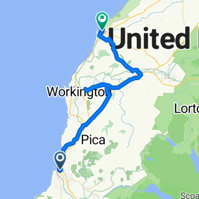
<span style="font-family: Arial,sans-serif;"><font size="4">Whitehaven</font></span>
<span style="font-family: Arial,sans-serif;">From slipway C2C sign go right on <span style="font-weight: normal;">West Strand to</span> L <span style="font-weight: normal;">on</span> <span style="font-weight: normal;">Quay St to </span>R <span style="font-weight: normal;">at TJ onto B5345</span></span>
<span style="font-family: Arial,sans-serif;"><span style="font-weight: normal;">Go</span> SO <span style="font-weight: normal;">at</span> <span style="font-weight: normal;">both</span> <span style="font-weight: normal;">rdbts past</span> <span style="font-weight: normal;">Aldi then </span>L <span style="font-weight: normal;">imm after Focus DIY store (since closed) onto C2C cyclepath</span></span>
<span style="font-family: Arial,sans-serif;"><span style="font-weight: normal;">In 0.2m </span>R<span style="font-weight: normal;">&</span>L <span style="font-weight: normal;">across Coach Rd. Cont</span> <span style="font-weight: normal;">under rly bridge to </span>R <span style="font-weight: normal;">at TJ onto Esk Av.</span></span>
<span style="font-family: Arial,sans-serif;">In 250yds R off Esk Av by school on C2C path. Go under rly bridge to fork L on path by rly</span>
<span style="font-family: Arial,sans-serif;">then to Croasdale Av. In 190 yds L to Wadsdale Cls then after 100yds L under rly bridge (ignore yellow C2C signs for walkers) R on C2C path for 7.8m around West Cumbria Field Centre. Path ends at TJ where L onto road for 415yds then R by school to</span>
<span style="font-family: Arial,sans-serif;"><font size="4">Kirkland</font></span>
<span style="font-family: Arial,sans-serif;"><span style="font-weight: normal;">At X-rds in village </span>L <span style="font-weight: normal;">(sp Lamplugh/Cockermouth) for 1m to </span>R <span style="font-weight: normal;">on A5086.</span></span>
<span style="font-family: Arial,sans-serif;"><span style="font-weight: normal;">In 0.38m </span>R <span style="font-weight: normal;">(sp Lamplugh/Loweswater). In 0.6m</span> <span style="font-weight: normal;">pass Dockray Meadow then short climb to</span> </span>
<span style="font-family: Arial,sans-serif;"><font size="4">Lamplugh</font></span>
<span style="font-family: Arial,sans-serif;">R (sp Loweswater) for 4m past Loweswater (before village ignore C2C left sign to Lorton)</span>
<span style="font-family: Arial,sans-serif;"><font size="4">Loweswater</font></span>
<span style="font-family: Arial,sans-serif;">SO <span style="font-weight: normal;">past Kirkstiles Inn and Church</span> <span style="font-weight: normal;">then</span> <span style="font-weight: normal;">bear left at next jnct to bridge over River Cocker. Climb up Scale Hill then after 1m </span>R <span style="font-weight: normal;">(sp Hopebeck) for 0.8m then </span>R <span style="font-weight: normal;">(sp Keswick narrow gated road)</span> <span style="font-weight: normal;">then 2m to </span>R <span style="font-weight: normal;">onto B5292 to</span> Whinlatter Pass <span style="font-weight: normal;">then stay on B5292 down to</span></span>
<span style="font-family: Arial,sans-serif;"><font size="4">Braithwaite</font></span>
<span style="font-family: Arial,sans-serif;">L <span style="font-weight: normal;">imm after sp Keswick/Cockermouth</span> <span style="font-weight: normal;">to</span> R <span style="font-weight: normal;">at TJ past</span> <span style="font-weight: normal;">Ivy House (green building)</span></span>
<span style="font-family: Arial,sans-serif;">L <span style="font-weight: normal;">In 0.45m (sp Swinside and weak bridge) then across Newlands Beck</span></span>
<span style="font-family: Arial,sans-serif;"><span style="font-weight: normal;">Next </span>L <span style="font-weight: normal;">to </span>Portinscale <span style="font-weight: normal;">where </span>R <span style="font-weight: normal;">as road bends left then dismount to cross suspension footbridge. In 300yds </span>R <span style="font-weight: normal;">on B5289 then </span>SO <span style="font-weight: normal;">to cross</span> <span style="font-weight: normal;">River Greta into</span></span>
<span style="font-family: Arial,sans-serif;"><font size="4">Keswick</font></span>
<span style="font-family: Arial,sans-serif;">Follow A5271 thru town, past pedestrian precinct and mining museum to</span>
<span style="font-family: Arial,sans-serif;">L <span style="font-weight: normal;">at lights onto Station Rd then across River Greta to</span> <span style="font-weight: normal;">access L shared path by swimming pool.. (2nd L path marked disabled access is more direct)<br /></span></span>
<span style="font-family: Arial,sans-serif;"><span style="font-weight: normal;">Bear round to right to</span> <span style="font-weight: normal;">access railpath</span> <span style="font-weight: normal;">to Threlkeld.</span> <span style="font-weight: normal;">After</span> <span style="font-weight: normal;">3m path is by A66</span> <span style="font-weight: normal;">then next </span>L <span style="font-weight: normal;">to</span></span>
<span style="font-family: Arial,sans-serif;"><font size="4">Threlkeld</font></span>
<span style="font-family: Arial,sans-serif;">Cont thru village to L (before A66). In 0.33m thru gate to re-join cycepath then by A66</span>
<span style="font-family: Arial,sans-serif;">After 0.8m L at Scales to pass Whitehorse Inn. Ignore C2C sign to Mungrisdale but return by A66 for 150yds. R on UC road for 1.6m past Caravan site then R onto C2C path by A66</span>
<span style="font-family: Arial,sans-serif;">After 0.45m L nr Troutbeck then 2.4m to L at Sportsman's Inn. In 0.65m R for 2.7m into</span>
<span style="font-family: Arial,sans-serif;"><font size="4">Greystoke</font></span>
<span style="font-family: Arial,sans-serif;">L <span style="font-weight: normal;">at xrds</span> <span style="font-weight: normal;">(sp </span>Blencow<span style="font-weight: normal;">)</span> <span style="font-weight: normal;">by stone cross</span></span>
<span style="font-family: Arial,sans-serif;">Cont <span style="font-weight: normal;">past Greystoke Cycle Cafe. After 1.8m </span>R <span style="font-weight: normal;">(sp Laithes/Penrith)</span> <span style="font-weight: normal;">to</span></span>
<span style="font-family: Arial,sans-serif;"><font size="4">Laithes</font></span>
<span style="font-family: Arial,sans-serif;"><font size="3">L<span style="font-weight: normal;"> after village on narrow lane for 175yds to </span>L<span style="font-weight: normal;"> at TJ</span></font></span>
<span style="font-family: Arial,sans-serif;"><font size="3">After 0.55m road bend right then next L for 0.8m to R at TJ on B5305 to rdbt across M6</font></span>
<span style="font-family: Arial,sans-serif;"><font size="3">Cont on B5305 over rlwy to next rdbt crossing A6 then exit L (sp Bowscar/Gt Salkeld)</font></span>
<span style="font-family: Arial,sans-serif;"><font size="3">Cont SO up Bowscar Rd for 1.8m then L on Salkeld Rd for 1.8m to</font></span>
<span style="font-family: Arial,sans-serif;"><font size="4">North Dykes</font></span>
<span style="font-family: Arial,sans-serif;">L <span style="font-weight: normal;">by conifers (sp Lazenby) for 0.7m to </span>L <span style="font-weight: normal;">at TJ onto B6412 for 1m to</span></span>
<span style="font-family: Arial,sans-serif;"><font size="4">Lazenby</font></span>
<span style="font-family: Arial,sans-serif;">R <span style="font-weight: normal;">at TJ onto B6413 under rly then</span> <span style="font-weight: normal;">across River Eden</span> <span style="font-weight: normal;">to</span></span>
<span style="font-family: Arial,sans-serif;"><font size="4">Kirkoswald</font></span>
<span style="font-family: Arial,sans-serif;">bear round to left. The Featheston Arms is a further 200yds and on the right.</span>
<span style="font-family: Arial,sans-serif;"><font size="4">Day2 Kikoswald to Rookhope</font></span>
<span style="font-family: Arial,sans-serif;"><font size="4">Kirkoswald</font></span>
<span style="font-family: Arial,sans-serif;">Exit Fetherston Arms L past Village Shop to L (sp Glassonby/Alston) climb for 3.1m to</span>
<span style="font-family: Arial,sans-serif;">5 Road Ends where L at jctn (sp Renwick) then 0.7m to R at TJ (sp Haresceugh/Alston) </span>
<span style="font-family: Arial,sans-serif;">Cont with steep climbs for 2.5m to sharp L onto A686 then climb 1.5m to</span>
<span style="font-family: Arial,sans-serif;"><font size="4">Hartside Top</font></span>
<span style="font-family: Arial,sans-serif;"><span style="font-weight: normal;">Cont on A686 for 3.1m then fork </span>R <span style="font-weight: normal;">(sp Leadgate/Garigill)</span></span>
<span style="font-family: Arial,sans-serif;"><span style="font-weight: normal;">In1m </span>R <span style="font-weight: normal;">at TJ at Leadgate to bridge over Black Burn</span> <span style="font-weight: normal;">then</span> <span style="font-weight: normal;">3m on undulating road to</span></span>
<span style="font-family: Arial,sans-serif;"><font size="4">Garrigill</font></span>
<span style="font-family: Arial,sans-serif;">L by the village green to cross bridge (River South Tyne). Road bend left then after 0.3m</span>
<span style="font-family: Arial,sans-serif;">R just before chapel up steep hill. Cont SO across B6277 up Dowgang Hush alt 600m</span>
<span style="font-family: Arial,sans-serif;">warning, a steep descent ends at TJ here R to follow round round to left into</span>
<span style="font-family: Arial,sans-serif;"><font size="4">Nentheads</font></span>
<span style="font-family: Arial,sans-serif;">R at TJ onto A689 then steep climbing for 0.65m to L (sp Carr Shields/Allenheads) 522m </span>
<span style="font-family: Arial,sans-serif;">Continue climbing 0.76m to summit of Black Hill highest point on the C2C at 609m/2000ft</span>
<span style="font-family: Arial,sans-serif;">From Northumberland sign descend for just 0.8m to R at Coalcleugh (sp Allenheads)</span>
<span style="font-family: Arial,sans-serif;">Continue for further 3.5m to R at TJ then another 1.0m thru Ropehaugh into</span>
<span style="font-family: Arial,sans-serif;"><font size="4">Allenheads</font></span>
<span style="font-family: Arial,sans-serif;">Pass Allenheads Inn and Hemmel Coffee shop to SO across B6295 then for 5.8m</span>
<span style="font-family: Arial,sans-serif;">passing Rookhope Burn on the right, past the Grove Rake Mine and Lintzgarth Arch to</span>
<span style="font-family: Arial,sans-serif;"><font size="4">Rookhope</font></span>
R<span style="font-family: Arial,sans-serif;"><span style="font-weight: normal;">oad bends right past the Rookhope Inn bends then cont for 0.4m</span></span> <span style="font-family: Arial,sans-serif;"><span style="font-weight: normal;">to left turn to Stanhope The Old Vicarage is down the</span></span> <span style="font-family: Arial,sans-serif;"><span style="font-weight: normal;">drive opposite the jctn</span></span>
<span style="font-family: Arial,sans-serif;"><font size="4">Day3 Rookhope to Sunderland</font></span>
<span style="font-family: Arial,sans-serif;"><font size="4">Rookhope</font></span>
<span style="font-family: Arial,sans-serif;">From Old Vicarage turn L then 0.4m to return to centre of Rookhope where road bends left</span>
<span style="font-family: Arial,sans-serif;">R (sp Waskerly) to climb steep railway track incline onto Stanhope Moor</span>
<span style="font-family: Arial,sans-serif;">From top of incline cont for 1.6m to L off C2C up rough path for 0.25m to R onto road </span>
<span style="font-family: Arial,sans-serif;"><font size="3">In 2m SO onto B6278 then in 0.27m turn L by mining wagon onto rough road to</font></span>
<span style="font-family: Arial,sans-serif;"><font size="4">Parkhead Station Tea Room</font></span>
<span style="font-family: Arial,sans-serif;">Cont L on Waskerly Way across moorland passing Waskerly Reservoir on the right</span>
<span style="font-family: Arial,sans-serif;">In abt 8m at Rowley L&R across A68 back onto C2C path. </span>
<span style="font-family: Arial,sans-serif;">In 0.9m cross over the Hownsgill Viaduct 150 foot high.</span>
<span style="font-family: Arial,sans-serif;">After passing the Smelt Wagon and Terris Novalis sculptures path ends at rdbt in</span>
<span style="font-family: Arial,sans-serif;"><font size="4">Consett</font></span>
<span style="font-family: Arial,sans-serif;"><span style="font-weight: normal;">Cross road to</span> <span style="font-weight: normal;">cont </span>L <span style="font-weight: normal;">on shared pathway</span> <span style="font-weight: normal;">by A692. Descend</span> <span style="font-weight: normal;">and cross Knitsley Rd</span></span>
<span style="font-family: Arial,sans-serif;"><span style="font-weight: normal;">Return by A692</span> <span style="font-weight: normal;">then around Tesco</span> <span style="font-weight: normal;">to cross B6308 Delves Rd</span></span>
<span style="font-family: Arial,sans-serif;"><span style="font-weight: normal;">Cont</span> <span style="font-weight: normal;">by sports field, thru woods, across rd</span> <span style="font-weight: normal;">(to ind estate), thru woods</span> <span style="font-weight: normal;">to cross</span> <span style="font-weight: normal;">A692</span> <span style="font-weight: normal;">at</span> <span style="font-weight: normal;">rdbt </span></span>
<span style="font-family: Arial,sans-serif;"><font size="4">Leadgate</font></span>
<span style="font-family: Arial,sans-serif;"><span style="font-weight: normal;">In 300yds cross under Leadgate Rd to</span> L<span style="font-weight: normal;">&</span>R <span style="font-weight: normal;">at</span> <span style="font-weight: normal;">Garden Place onto path by South Cross St</span></span>
<span style="font-family: Arial,sans-serif;">SO <span style="font-weight: normal;">for 0.66m</span> <span style="font-weight: normal;">crossing</span> <span style="font-weight: normal;">B6309</span> <span style="font-weight: normal;">and St Ives Gardens</span> <span style="font-weight: normal;">to</span> <span style="font-weight: normal;">rdbt with A692.</span></span>
<span style="font-family: Arial,sans-serif;">Cross rdbt to path opposite, either ride round or walk to access C2C path</span>
<span style="font-family: Arial,sans-serif;">SO <span style="font-weight: normal;">for 2.0m,</span> <span style="font-weight: normal;">thru</span> <span style="font-weight: normal;">maze sculpture, past transformer sculptures then across Tower Rd</span> </span>
<span style="font-family: Arial,sans-serif;"><font size="4">Greencroft Industrial Park</font></span>
<span style="font-family: Arial,sans-serif;"><span style="font-weight: normal;">Follow</span> <span style="font-weight: normal;">path for 0.56m past</span> <span style="font-weight: normal;">pond on the left to</span> <span style="font-weight: normal;">cross Greencroft Parkway</span></span>
<span style="font-family: Arial,sans-serif;">SO <span style="font-weight: normal;">for</span> <span style="font-weight: normal;">175yds as</span> <span style="font-weight: normal;">path bend left then after 256yds bear right</span> <span style="font-weight: normal;">for bridge over A693</span></span>
<span style="font-family: Arial,sans-serif;"><span style="font-weight: normal;">Cont on St Aidan's Cres to rejoin cylepath on left then</span> <span style="font-weight: normal;">across Durham Rd at</span></span>
<span style="font-family: Arial,sans-serif;"><font size="4">Annfield Plain</font></span>
<span style="font-family: Arial,sans-serif;">Bear left to cont on path between low wall and houses down Mitchell Street</span>
<span style="font-family: Arial,sans-serif;"><span style="font-weight: normal;">Then</span> <span style="font-weight: normal;">for 10.2m on</span> <span style="font-weight: normal;">Consett and Sunderland railpath which goes</span> <span style="font-weight: normal;">North</span> <span style="font-weight: normal;">of </span>Stanley</span>
<span style="font-family: Arial,sans-serif;"><span style="font-weight: normal;">past Iron Cow sculpture south-east of </span>Beamish, <span style="font-weight: normal;">King Coal sculptures</span> <span style="font-weight: normal;">at </span>Pelton Fell</span>
<span style="font-family: Arial,sans-serif;"><span style="font-weight: normal;">passing North</span> <span style="font-weight: normal;">of </span>Chester-le-Street <span style="font-weight: normal;">to go under A1(M)</span> <span style="font-weight: normal;">towards</span></span>
<span style="font-family: Arial,sans-serif;"><font size="4">Washington</font></span>
<span style="font-family: Arial,sans-serif;"><span style="font-weight: normal;">Cross Biddick Ln</span> <span style="font-weight: normal;">then 0.3m to cross Shepherd Way by rdbt. In 90yds follow cyclepath thru woods</span> <span style="font-weight: normal;">then bear left to go under Leamside rly thru</span> <span style="font-weight: normal;">James Steel Park and by River Weir</span></span>
<span style="font-family: Arial,sans-serif;"><span style="font-weight: normal;">Bear left following</span> <span style="font-weight: normal;">C2C path</span> <span style="font-weight: normal;">up to</span> <span style="font-weight: normal;">bear right alongside Pattinson Rd </span></span>
<span style="font-family: Arial,sans-serif;">R <span style="font-weight: normal;">by</span> <span style="font-weight: normal;">rdbt then </span>L <span style="font-weight: normal;">in 85yds to cont on path</span> <span style="font-weight: normal;">for 260yds then</span> <span style="font-weight: normal;">turn sharp </span>R <span style="font-weight: normal;">by Wetlands Centre</span> <span style="font-weight: normal;">In 0.6m bear left round Scania site</span> <span style="font-weight: normal;">then in 125yds first</span> R <span style="font-weight: normal;">alongside A1231 then by A19</span></span>
<span style="font-family: Arial,sans-serif;"><span style="font-weight: normal;">Turn sharp </span>L <span style="font-weight: normal;">to go under A19 then descend to</span></span>
<span style="font-family: Arial,sans-serif;"><font size="4">North Hylton</font></span>
<span style="font-family: Arial,sans-serif;">L <span style="font-weight: normal;">on Ferryboat Ln up to next </span>R <span style="font-weight: normal;">onto Grange Rd for 166yds. </span>R <span style="font-weight: normal;">onto path just before bridge</span></span>
<span style="font-family: Arial,sans-serif;">R <span style="font-weight: normal;">in 0.33m by rdbt (opp BP station)</span> <span style="font-weight: normal;">on path to descend through wood then by</span> <span style="font-weight: normal;">River Weir.</span></span>
<span style="font-family: Arial,sans-serif;"><span style="font-weight: normal;">Follow path for 0.8m path to A1231</span> <span style="font-weight: normal;">Timber Beach Rd</span> <span style="font-weight: normal;">to bear </span>R <span style="font-weight: normal;">on shared path</span></span>
<span style="font-family: Arial,sans-serif;"><font size="4">Sunderland </font></span>
<span style="font-family: Arial,sans-serif;">Cont on path then R just after rdbt and away from Hylton Park Rd (or cont on for 410yds)</span>
<span style="font-family: Arial,sans-serif;">Path loops down towards River Weir then back up to Hylton Park Rd</span>
<span style="font-family: Arial,sans-serif;">R then L to rejoin path on opposite side of Hylton Park Rd by A1231. Pass under 2 bridges After Peugeot Garage imm R to descend on path then L on Wayfarer Rd behind IAC shed</span>
<span style="font-family: Arial,sans-serif;">Bear right on path down to follow path by River Weir for 1.8m past, Stadium of Light</span>
<span style="font-family: Arial,sans-serif;">under Weirmouth Bridge, by Sunderland University and National Glass Centre</span>
<span style="font-family: Arial,sans-serif;"><span style="font-weight: normal;">Turn </span>R <span style="font-weight: normal;">on Sand Point Rd then after</span> <span style="font-weight: normal;">200yds bear</span> <span style="font-weight: normal;">left around marina</span> </span>
<span style="font-family: Arial,sans-serif;">Cont by Sunderland Yacht Club onto Roker seafront.</span>
<span style="font-family: Arial,sans-serif;">The C2C granite marker is beyond the carpark and near the Watersports Centre.</span>
created this 15 years ago
Route quality
Cycleway
79.4 km
(39 %)
Quiet road
52.9 km
(26 %)
Paved
112 km
(55 %)
Unpaved
18.3 km
(9 %)
Asphalt
109.9 km
(54 %)
Gravel
10.2 km
(5 %)
Continue with Bikemap
You would like to ride Michael's 2011 C2C or customize it for your own trip? Here is what you can do with this Bikemap route:
Free trial for 3 days, or one-time payment. More about Bikemap Premium.
Discover more Premium features.
Get Bikemap PremiumFrom our community
Open it in the app