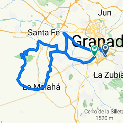
ALTO DE MONACHIL/ EL PURCHE (por Monachil)
A cycling route starting in HuƩtor Vega, Andalusia, Spain.
Overview
About this route
- -:--
- Duration
- 10.2 km
- Distance
- 722 m
- Ascent
- 19 m
- Descent
- ---
- Avg. speed
- ---
- Avg. speed
Route quality
Waytypes & surfaces along the route
Waytypes
Road
8.2 km
(80 %)
Pedestrian area
1.4 km
(14 %)
Surfaces
Paved
7.4 km
(72 %)
Asphalt
7.4 km
(72 %)
Undefined
2.9 km
(28 %)
Continue with Bikemap
Use, edit, or download this cycling route
You would like to ride ALTO DE MONACHIL/ EL PURCHE (por Monachil) or customize it for your own trip? Here is what you can do with this Bikemap route:
Free features
- Save this route as favorite or in collections
- Copy & plan your own version of this route
- Sync your route with Garmin or Wahoo
Premium features
Free trial for 3 days, or one-time payment. More about Bikemap Premium.
- Navigate this route on iOS & Android
- Export a GPX / KML file of this route
- Create your custom printout (try it for free)
- Download this route for offline navigation
Discover more Premium features.
Get Bikemap PremiumFrom our community
Other popular routes starting in HuƩtor Vega
- Canal de los franceses
- Distance
- 16.6 km
- Ascent
- 495 m
- Descent
- 422 m
- Location
- HuƩtor Vega, Andalusia, Spain
- Los Cahorros de Monachil-TK001
- Distance
- 23.3 km
- Ascent
- 506 m
- Descent
- 508 m
- Location
- HuƩtor Vega, Andalusia, Spain
- Barranco de San Juan
- Distance
- 23.3 km
- Ascent
- 703 m
- Descent
- 248 m
- Location
- HuƩtor Vega, Andalusia, Spain
- 10-8-10 Llano de la Perdiz (made in Antonio Aguilera) (IBP: 53)
- Distance
- 29.2 km
- Ascent
- 544 m
- Descent
- 544 m
- Location
- HuƩtor Vega, Andalusia, Spain
- GR-Gojar-Ermita Vieja-Dilar-Gojar-GR
- Distance
- 38.8 km
- Ascent
- 797 m
- Descent
- 798 m
- Location
- HuƩtor Vega, Andalusia, Spain
- Canal de La Espartera-TK004
- Distance
- 26.4 km
- Ascent
- 805 m
- Descent
- 626 m
- Location
- HuƩtor Vega, Andalusia, Spain
- Llano de La Perdiz-TK005
- Distance
- 27.3 km
- Ascent
- 482 m
- Descent
- 482 m
- Location
- HuƩtor Vega, Andalusia, Spain
- Embalse de Canales
- Distance
- 30.8 km
- Ascent
- 565 m
- Descent
- 566 m
- Location
- HuƩtor Vega, Andalusia, Spain