

Wiesensteig und Breitenstein
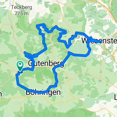
A cycling route starting in Grabenstetten, Baden-Württemberg, Germany.
Overview
About this route
Bunt gemischte MTB-Tour mit mehreren asphaltierten Anstiegen, und einzelnen Downhill- und Trail-Intermezzos, die sich jedoch auch umgehen lassen. Der größte Teil verläuft auf ruhigeren Wald- und Wirtschaftswegen. Besonders nett ist die Aussicht am Breitensteinfels. Wenn die Strecke nicht gerade gesperrt ist, kann man vom Bahnhöfle auch direkt nach Neidlingen abkürzen.
- -:--
- Duration
- 55 km
- Distance
- 824 m
- Ascent
- 824 m
- Descent
- ---
- Avg. speed
- ---
- Avg. speed

Route quality
Waytypes & surfaces along the route
Waytypes
Track
30.5 km
(55 %)
Busy road
12.9 km
(23 %)
Surfaces
Paved
37.3 km
(68 %)
Unpaved
13.1 km
(24 %)
Asphalt
31.9 km
(58 %)
Gravel
6.4 km
(12 %)
Continue with Bikemap
Use, edit, or download this cycling route
You would like to ride Wiesensteig und Breitenstein or customize it for your own trip? Here is what you can do with this Bikemap route:
Free features
- Save this route as favorite or in collections
- Copy & plan your own version of this route
- Sync your route with Garmin or Wahoo
Premium features
Free trial for 3 days, or one-time payment. More about Bikemap Premium.
- Navigate this route on iOS & Android
- Export a GPX / KML file of this route
- Create your custom printout (try it for free)
- Download this route for offline navigation
Discover more Premium features.
Get Bikemap PremiumFrom our community
Other popular routes starting in Grabenstetten
 Albcrossi
- Distance
- 53.2 km
- Ascent
- 847 m
- Descent
- 851 m
- Location
- Grabenstetten, Baden-Württemberg, Germany
 Pfulb - Boehringen
- Distance
- 5.9 km
- Ascent
- 104 m
- Descent
- 82 m
- Location
- Grabenstetten, Baden-Württemberg, Germany
 RD/PTH 2014
- Distance
- 46.2 km
- Ascent
- 796 m
- Descent
- 796 m
- Location
- Grabenstetten, Baden-Württemberg, Germany
 Grabenstetten - MTB-Rundtour
- Distance
- 44.9 km
- Ascent
- 937 m
- Descent
- 880 m
- Location
- Grabenstetten, Baden-Württemberg, Germany
 Boehringen - Feldstetten 1
- Distance
- 10.7 km
- Ascent
- 132 m
- Descent
- 122 m
- Location
- Grabenstetten, Baden-Württemberg, Germany
 Grabenstetten - Rundtour 1
- Distance
- 38.4 km
- Ascent
- 761 m
- Descent
- 760 m
- Location
- Grabenstetten, Baden-Württemberg, Germany
 Wiesensteig und Breitenstein
- Distance
- 55 km
- Ascent
- 824 m
- Descent
- 824 m
- Location
- Grabenstetten, Baden-Württemberg, Germany
 truppenübung
- Distance
- 48.3 km
- Ascent
- 491 m
- Descent
- 527 m
- Location
- Grabenstetten, Baden-Württemberg, Germany
Open it in the app