

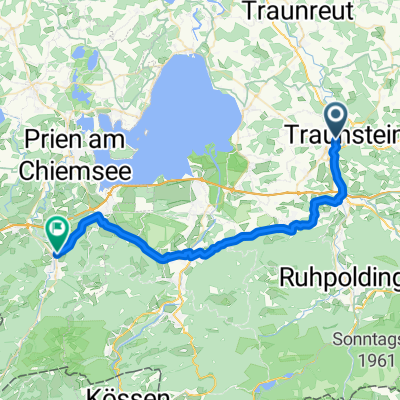
Traunstein-Chieming-Traunstein
A cycling route starting in Traunstein, Bavaria, Germany.
Overview
About this route
- -:--
- Duration
- 26.3 km
- Distance
- 210 m
- Ascent
- 209 m
- Descent
- ---
- Avg. speed
- ---
- Max. altitude

Route quality
Waytypes & surfaces along the route
Waytypes
Quiet road
14.2 km
(54 %)
Path
5 km
(19 %)
Surfaces
Paved
21.8 km
(83 %)
Unpaved
2.6 km
(10 %)
Asphalt
21.8 km
(83 %)
Gravel
1.3 km
(5 %)
Continue with Bikemap
Use, edit, or download this cycling route
You would like to ride Traunstein-Chieming-Traunstein or customize it for your own trip? Here is what you can do with this Bikemap route:
Free features
- Save this route as favorite or in collections
- Copy & plan your own version of this route
- Sync your route with Garmin or Wahoo
Premium features
Free trial for 3 days, or one-time payment. More about Bikemap Premium.
- Navigate this route on iOS & Android
- Export a GPX / KML file of this route
- Create your custom printout (try it for free)
- Download this route for offline navigation
Discover more Premium features.
Get Bikemap PremiumFrom our community
Other popular routes starting in Traunstein
 Traunstein nach Aschau
- Distance
- 37.6 km
- Ascent
- 475 m
- Descent
- 467 m
- Location
- Traunstein, Bavaria, Germany
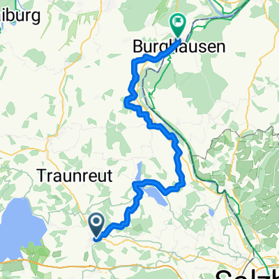 Traunstein - Burghausen
- Distance
- 66.7 km
- Ascent
- 516 m
- Descent
- 690 m
- Location
- Traunstein, Bavaria, Germany
 Gut Edermann über Siegsdorf
- Distance
- 43.4 km
- Ascent
- 348 m
- Descent
- 348 m
- Location
- Traunstein, Bavaria, Germany
 Chiemsee 80k
- Distance
- 81.2 km
- Ascent
- 372 m
- Descent
- 372 m
- Location
- Traunstein, Bavaria, Germany
 Traunstein-Chieming-Traunstein
- Distance
- 26.3 km
- Ascent
- 210 m
- Descent
- 209 m
- Location
- Traunstein, Bavaria, Germany
 Traunstein - Schönau am Königsee
- Distance
- 58.7 km
- Ascent
- 382 m
- Descent
- 280 m
- Location
- Traunstein, Bavaria, Germany
 TS - Stoißer Alm - Bäckeralm - TS
- Distance
- 50.4 km
- Ascent
- 931 m
- Descent
- 930 m
- Location
- Traunstein, Bavaria, Germany
 Brauereitour 2 - Chiemsee und Alz, Hopfen und Malz
- Distance
- 62.7 km
- Ascent
- 608 m
- Descent
- 609 m
- Location
- Traunstein, Bavaria, Germany
Open it in the app