İzmit Turu
A cycling route starting in Köseköy, Kocaeli Province, Turkey.
Overview
About this route
- 2 h 38 min
- Duration
- 73.1 km
- Distance
- 8 m
- Ascent
- 10 m
- Descent
- 27.8 km/h
- Avg. speed
- ---
- Avg. speed
Route photos
Continue with Bikemap
Use, edit, or download this cycling route
You would like to ride İzmit Turu or customize it for your own trip? Here is what you can do with this Bikemap route:
Free features
- Save this route as favorite or in collections
- Copy & plan your own version of this route
- Sync your route with Garmin or Wahoo
Premium features
Free trial for 3 days, or one-time payment. More about Bikemap Premium.
- Navigate this route on iOS & Android
- Export a GPX / KML file of this route
- Create your custom printout (try it for free)
- Download this route for offline navigation
Discover more Premium features.
Get Bikemap PremiumFrom our community
Other popular routes starting in Köseköy
- Tanrıkulu Sokak 19 to Gazanfer Bilge Sokak
- Distance
- 10.4 km
- Ascent
- 31 m
- Descent
- 46 m
- Location
- Köseköy, Kocaeli Province, Turkey
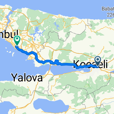
- İzmit-Köseköy-Çenesuyu-Başiskele
- Distance
- 74.4 km
- Ascent
- 191 m
- Descent
- 198 m
- Location
- Köseköy, Kocaeli Province, Turkey
- Park İçi Yolu, İzmit to Bağdat Cd., İzmit
- Distance
- 5.1 km
- Ascent
- 18 m
- Descent
- 13 m
- Location
- Köseköy, Kocaeli Province, Turkey
- ballikayalar
- Distance
- 65.2 km
- Ascent
- 945 m
- Descent
- 822 m
- Location
- Köseköy, Kocaeli Province, Turkey
- Metehan Sokak 4 to Akasyalar Caddesi 2
- Distance
- 8.3 km
- Ascent
- 28 m
- Descent
- 54 m
- Location
- Köseköy, Kocaeli Province, Turkey
- Akasyalar Caddesi 1 to Cennet Sokak 2
- Distance
- 31.8 km
- Ascent
- 331 m
- Descent
- 293 m
- Location
- Köseköy, Kocaeli Province, Turkey
- T-G 2013 Etappe 03
- Distance
- 74.2 km
- Ascent
- 596 m
- Descent
- 423 m
- Location
- Köseköy, Kocaeli Province, Turkey
- İzmit Turu
- Distance
- 73.1 km
- Ascent
- 8 m
- Descent
- 10 m
- Location
- Köseköy, Kocaeli Province, Turkey
Open it in the app