

Haute-Nendaz par Isérables
A cycling route starting in Riddes, Valais, Switzerland.
Overview
About this route
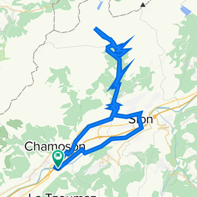
Climb to the picturesque village of Isérables, which is crossed by steep ramps before following a small road that winds through the mountain up to Haute-Nendaz. To avoid traffic, return via Fey Aproz.
- -:--
- Duration
- 42.9 km
- Distance
- 1,213 m
- Ascent
- 1,213 m
- Descent
- ---
- Avg. speed
- ---
- Max. altitude

Continue with Bikemap
Use, edit, or download this cycling route
You would like to ride Haute-Nendaz par Isérables or customize it for your own trip? Here is what you can do with this Bikemap route:
Free features
- Save this route as favorite or in collections
- Copy & plan your own version of this route
- Sync your route with Garmin or Wahoo
Premium features
Free trial for 3 days, or one-time payment. More about Bikemap Premium.
- Navigate this route on iOS & Android
- Export a GPX / KML file of this route
- Create your custom printout (try it for free)
- Download this route for offline navigation
Discover more Premium features.
Get Bikemap PremiumFrom our community
Other popular routes starting in Riddes
 Riddes to Savoleyres
- Distance
- 24.3 km
- Ascent
- 1,926 m
- Descent
- 29 m
- Location
- Riddes, Valais, Switzerland
 La Tzoumaz, Randonnée à raquettes, La Tzoumaz - Savoleyres (3)
- Distance
- 4.2 km
- Ascent
- 829 m
- Descent
- 15 m
- Location
- Riddes, Valais, Switzerland
 Riddes to La Tzoumaz
- Distance
- 13.6 km
- Ascent
- 1,096 m
- Descent
- 0 m
- Location
- Riddes, Valais, Switzerland
 Thyon 2000 par Euseigne, retour par Isérables
- Distance
- 79.7 km
- Ascent
- 2,010 m
- Descent
- 2,010 m
- Location
- Riddes, Valais, Switzerland
 Coteaux rive gauche
- Distance
- 90.6 km
- Ascent
- 1,899 m
- Descent
- 1,890 m
- Location
- Riddes, Valais, Switzerland
 Col du Sanetsch
- Distance
- 72.8 km
- Ascent
- 2,345 m
- Descent
- 2,344 m
- Location
- Riddes, Valais, Switzerland
 Isérables - Verbier
- Distance
- 23.1 km
- Ascent
- 1,224 m
- Descent
- 841 m
- Location
- Riddes, Valais, Switzerland
 Le Giro
- Distance
- 8.8 km
- Ascent
- 697 m
- Descent
- 42 m
- Location
- Riddes, Valais, Switzerland
Open it in the app