
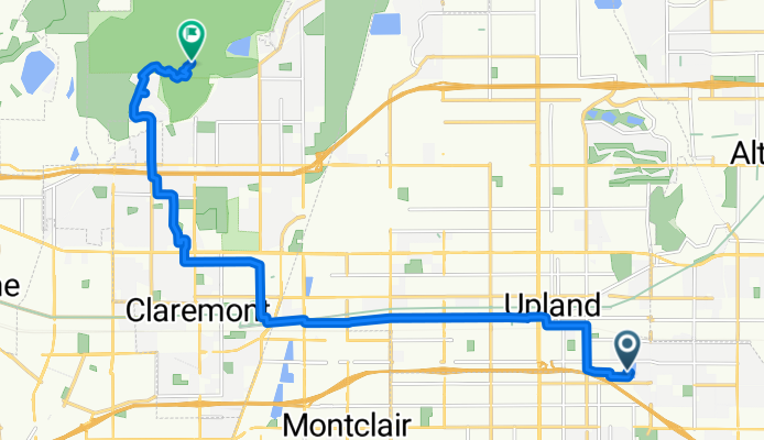
Route from 1053 E Sixth St, Upland
A cycling route starting in Upland, California, United States of America.
Overview
About this route
- 1 h
- Duration
- 17 km
- Distance
- 343 m
- Ascent
- 150 m
- Descent
- 17 km/h
- Avg. speed
- ---
- Max. altitude
Route quality
Waytypes & surfaces along the route
Waytypes
Road
5.7 km
(34 %)
Quiet road
5.2 km
(31 %)
Surfaces
Paved
11.7 km
(69 %)
Unpaved
1.8 km
(11 %)
Asphalt
11.3 km
(66 %)
Ground
1.8 km
(11 %)
Continue with Bikemap
Use, edit, or download this cycling route
You would like to ride Route from 1053 E Sixth St, Upland or customize it for your own trip? Here is what you can do with this Bikemap route:
Free features
- Save this route as favorite or in collections
- Copy & plan your own version of this route
- Sync your route with Garmin or Wahoo
Premium features
Free trial for 3 days, or one-time payment. More about Bikemap Premium.
- Navigate this route on iOS & Android
- Export a GPX / KML file of this route
- Create your custom printout (try it for free)
- Download this route for offline navigation
Discover more Premium features.
Get Bikemap PremiumFrom our community
Other popular routes starting in Upland
 Pacific Electric Trail, Upland to 11200 Baseline Rd, Rancho Cucamonga
- Distance
- 9.1 km
- Ascent
- 69 m
- Descent
- 30 m
- Location
- Upland, California, United States of America
 249–271 E A St, Upland to 210 E A St, Upland
- Distance
- 49.7 km
- Ascent
- 376 m
- Descent
- 375 m
- Location
- Upland, California, United States of America
 North Euclid Avenue 390, Upland to Newport Boulevard 3600, Newport Beach
- Distance
- 74.3 km
- Ascent
- 368 m
- Descent
- 745 m
- Location
- Upland, California, United States of America
 Foothill Boulevard 8318, Rancho Cucamonga to Woodstream Court 7537, Rancho Cucamonga
- Distance
- 12.9 km
- Ascent
- 13 m
- Descent
- 14 m
- Location
- Upland, California, United States of America
 North Campus Avenue 329, Upland to Olive Street 4948, Montclair
- Distance
- 5.9 km
- Ascent
- 24 m
- Descent
- 370 m
- Location
- Upland, California, United States of America
 North Mountain Avenue 306, Upland to North Mountain Avenue 306, Upland
- Distance
- 31.7 km
- Ascent
- 139 m
- Descent
- 139 m
- Location
- Upland, California, United States of America
 148 W Seventh St, Upland to 8300 Utica Ave, Rancho Cucamonga
- Distance
- 8.9 km
- Ascent
- 36 m
- Descent
- 27 m
- Location
- Upland, California, United States of America
 Route from 1053 E Sixth St, Upland
- Distance
- 17 km
- Ascent
- 343 m
- Descent
- 150 m
- Location
- Upland, California, United States of America
Open it in the app