
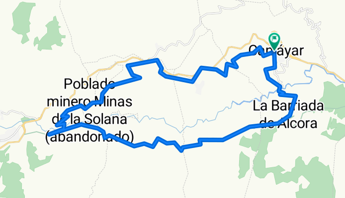
Canjayar-alcora-minas almocita-boliñeva
A cycling route starting in Canjáyar, Andalusia, Spain.
Overview
About this route
The last stretch of Bolivia is quite bad.
- -:--
- Duration
- 31.5 km
- Distance
- 736 m
- Ascent
- 736 m
- Descent
- ---
- Avg. speed
- ---
- Max. altitude

Continue with Bikemap
Use, edit, or download this cycling route
You would like to ride Canjayar-alcora-minas almocita-boliñeva or customize it for your own trip? Here is what you can do with this Bikemap route:
Free features
- Save this route as favorite or in collections
- Copy & plan your own version of this route
- Sync your route with Garmin or Wahoo
Premium features
Free trial for 3 days, or one-time payment. More about Bikemap Premium.
- Navigate this route on iOS & Android
- Export a GPX / KML file of this route
- Create your custom printout (try it for free)
- Download this route for offline navigation
Discover more Premium features.
Get Bikemap PremiumFrom our community
Other popular routes starting in Canjáyar
 Canjayar - Padules - Almocita - Alcora
- Distance
- 35.8 km
- Ascent
- 840 m
- Descent
- 830 m
- Location
- Canjáyar, Andalusia, Spain
 Canjáyar-Ohanes-BUITRE
- Distance
- 70.6 km
- Ascent
- 1,982 m
- Descent
- 1,989 m
- Location
- Canjáyar, Andalusia, Spain
 CANJÁYAR-BARJALÍ
- Distance
- 59 km
- Ascent
- 1,449 m
- Descent
- 1,449 m
- Location
- Canjáyar, Andalusia, Spain
 ALCORA-AGUADULCE
- Distance
- 74.4 km
- Ascent
- 2,462 m
- Descent
- 2,524 m
- Location
- Canjáyar, Andalusia, Spain
 canjayar-alcora-padules
- Distance
- 16.7 km
- Ascent
- 563 m
- Descent
- 563 m
- Location
- Canjáyar, Andalusia, Spain
 2ª CICLOTURISTA SANTA CRUZ-CANJÁYAR
- Distance
- 61.4 km
- Ascent
- 1,454 m
- Descent
- 1,438 m
- Location
- Canjáyar, Andalusia, Spain
 ALCORA-BARJALÍ
- Distance
- 58.9 km
- Ascent
- 1,235 m
- Descent
- 1,298 m
- Location
- Canjáyar, Andalusia, Spain
 Canjayar - Enix - Almeria
- Distance
- 70 km
- Ascent
- 1,253 m
- Descent
- 1,797 m
- Location
- Canjáyar, Andalusia, Spain
Open it in the app