Frauen-MSR (100 km) 2025
- 108 km
- 665 m
- 667 m
- Neubrandenburg, Mecklenburg-Vorpommern, Germany
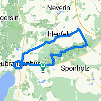
A cycling route starting in Neubrandenburg, Mecklenburg-Vorpommern, Germany.
Overview
Neubrandenburg
· City of Four Gates on Lake Tollensese
· Medieval fortifications
· Concert church
· Theater
· Museums
· Model park "Mecklenburg Lake District"
· Shopping miles
· Art collection
· Cultural park
· Town hall
· Jahnsportforum
· 2 large outdoor pools (Augustabad and Strandbad Broda)
· Boat and bike rental
· Waterskiing on Lake Reitbahnsee
· Gastronomy
Nemerower Holz
· Observation tower Behmshöhe
· Arionstein
Klein Nemerow
· Stone barn of a former Commandery of the Knights Hospitaller
· Gastronomy, passenger ship dock
· Beach
Usadel
· Wonderful view over the Lieps
· Gastronomy
Prillwitz
· Hunting lodge (19th century) with park and gastronomy
· Church
· Early German castle hill
· Swimming spot
· Passenger ship dock
· Restaurant
Wendfeld
· Detour to the Hellberge nature reserve
· Viewpoint over the entire Tollense basin
Alt Rehse
· Permanent exhibition on the Imperial School of Medicine
· Church
· Unique village ensemble with half-timbered houses
· Restaurant
· Village community center (Wossidlosprüche)
Route Characteristics:
Independently maintained cycling/hiking path, little-used side roads, southern area between Klein Nemerow and Alt Rehse is very hilly
created this 5 years ago
Route quality
Path
14.9 km
(41 %)
Track
7.6 km
(21 %)
Paved
14.5 km
(40 %)
Unpaved
11.6 km
(32 %)
Asphalt
13.1 km
(36 %)
Loose gravel
7.6 km
(21 %)
Continue with Bikemap
You would like to ride Tollensesee-Radrundweg or customize it for your own trip? Here is what you can do with this Bikemap route:
Free trial for 3 days, or one-time payment. More about Bikemap Premium.
Discover more Premium features.
Get Bikemap PremiumFrom our community
Open it in the app