

Le Beaujolais en VTT
A cycling route starting in Gleizé, Auvergne-Rhône-Alpes, France.
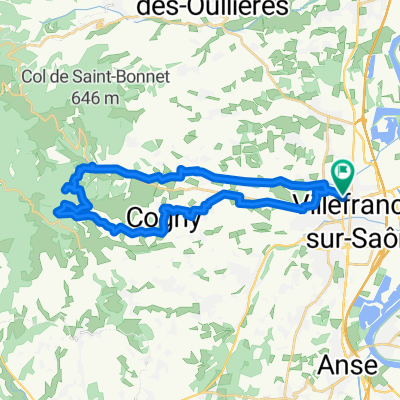
Overview
About this route
<p>Start: sports hall parking lot</p>
<p>long climb on road</p>
<p>long descent on paths and trails</p>
Translated, show original (French)- -:--
- Duration
- 29.9 km
- Distance
- 636 m
- Ascent
- 633 m
- Descent
- ---
- Avg. speed
- ---
- Max. altitude

Route highlights
Points of interest along the route
Point of interest after 0 km
Gymnase (point d'eau extérieur)
Point of interest after 0.8 km
Chapelle d'Ouilly
Point of interest after 9.6 km
Auberge fontaine d'eau (en face)
Point of interest after 12.3 km
Chapelle de Saint Bonnet (XIIIeme siècle) vue panoramique
Point of interest after 13.4 km
col de Saint Bonnet
Point of interest after 15.9 km
"la roche" accès par un petit sentier sur la droite (environ 30m)
Point of interest after 16.7 km
parc accrobranche
Point of interest after 20.3 km
Vierge bleue (promontoir)
Continue with Bikemap
Use, edit, or download this cycling route
You would like to ride Le Beaujolais en VTT or customize it for your own trip? Here is what you can do with this Bikemap route:
Free features
- Save this route as favorite or in collections
- Copy & plan your own version of this route
- Sync your route with Garmin or Wahoo
Premium features
Free trial for 3 days, or one-time payment. More about Bikemap Premium.
- Navigate this route on iOS & Android
- Export a GPX / KML file of this route
- Create your custom printout (try it for free)
- Download this route for offline navigation
Discover more Premium features.
Get Bikemap PremiumFrom our community
Other popular routes starting in Gleizé
 beaujolais training
- Distance
- 43.4 km
- Ascent
- 438 m
- Descent
- 438 m
- Location
- Gleizé, Auvergne-Rhône-Alpes, France
 Motocross de Lamure
- Distance
- 51.7 km
- Ascent
- 989 m
- Descent
- 990 m
- Location
- Gleizé, Auvergne-Rhône-Alpes, France
 Chapelle de Saint Bonnet
- Distance
- 24.6 km
- Ascent
- 467 m
- Descent
- 467 m
- Location
- Gleizé, Auvergne-Rhône-Alpes, France
 Beaujomais sud
- Distance
- 31.4 km
- Ascent
- 529 m
- Descent
- 526 m
- Location
- Gleizé, Auvergne-Rhône-Alpes, France
 Chemin de la Rippe, Gleizé a Chemin de la Rippe, Gleizé
- Distance
- 12 km
- Ascent
- 155 m
- Descent
- 156 m
- Location
- Gleizé, Auvergne-Rhône-Alpes, France
 VTT Bitume
- Distance
- 41.2 km
- Ascent
- 661 m
- Descent
- 658 m
- Location
- Gleizé, Auvergne-Rhône-Alpes, France
 Le Beaujolais en VTT
- Distance
- 29.9 km
- Ascent
- 636 m
- Descent
- 633 m
- Location
- Gleizé, Auvergne-Rhône-Alpes, France
 Beaujolais village
- Distance
- 43.7 km
- Ascent
- 607 m
- Descent
- 607 m
- Location
- Gleizé, Auvergne-Rhône-Alpes, France
Open it in the app